Below the Size Threshold: How Two Small Glacial Lakes Cascaded Into Thame, and Why Nobody Died

The people of Thame heard it before they saw it. The village sits high in Nepal's Everest region, a short walk up the valley from Namche Bazar, the trekking gateway to the Khumbu, and what came down the channel on the afternoon of 16 August 2024 was not the river. It was roughly 770,000 cubic meters of water that had been standing in two small glacial lakes about nine kilometers upstream, arriving as a debris-laden flood. It destroyed tea houses, wrecked the primary school, cut long sections of trekking trail, and displaced 135 people. No one was killed.
That last fact is not an accident of the terrain alone, and explaining it is the most useful thing in a reconstruction of the flood published on 27 August in Natural Hazards and Earth System Sciences. About halfway down the valley, just below a seasonal grazing settlement called Thengpo Kharka, the floor opens onto a plain of sand about half a kilometer long. The flood spread out across it and briefly ponded there, which flattened the front of the wave and slowed it down. Nitesh Khadka, Vishnu Prasad Pandey, and eight colleagues found the ponding in the field and reproduced it in their model, and wrote that the temporary storage "provided critical lead time for residents of Thame Village to evacuate safely."
The two-year gap between the flood and the paper is the point of it. A government helicopter survey the following day had already identified the cause as an outburst from glacial lakes in the headwaters. What took longer was establishing that there had been two of them, in series: the upper lake overtopped its dam, and the surge that came down the rock step below it broke into the lower lake and breached that dam as well. The paper calls this a cascading outburst, a hazard chain that conventional risk assessment rarely models.
Two lakes that were too small to be on the list
Neither lake was on anyone's watchlist, and the reason is a number. The Everest region's dangerous glacial lakes are the famous ones: Imja Tsho and Tsho Rolpa, each covering well over a square kilometer, each surveyed, modeled, and worked on to bring the risk down. Regional and national assessments find lakes like those by screening satellite inventories for water bodies above a minimum size, and the usual cut-off sits around a tenth of a square kilometer. The upper Ngole lake spent nearly all of its short life underneath that line. It formed in the late 2000s as its parent glacier retreated, and by the time it burst it measured 0.11 square kilometers, over the threshold by a rounding error, and only just before it failed.
The lower lake, Ngole Pokhari, is older, and it put on a fifth of more area over recent decades. One study did have both of them on a list: an assessment covering all of High Mountain Asia included them and rated the upper lake a high outburst hazard. But the national and basin-scale assessments that Nepali agencies work from left them out, and the authors are explicit that minimum size thresholds are why.
What the model can pin down, and what it cannot
To reconstruct what happened between the two lakes, the team ran r.avaflow, an open-source mass-flow simulator anyone can download, over an elevation model built from a drone survey of the valley. They tried two versions of the lower dam's failure. In one, the surge from above arrived as a wave that topped the crest and cut down through the moraine; in the other, the inflow simply filled the lake until it spilled. Both reproduce the flooded area about equally well. What separates them is the ground. The depth and reach of the scour along the channel between the lakes match the sudden wave, and on that evidence, the authors call it the more plausible reconstruction.
The model is also where the flood's speed comes from. Under the wave scenario, it puts the front at Thame roughly 22 minutes after the first dam gave way; under the slower one, roughly 15. Nobody stood in the village with a stopwatch.
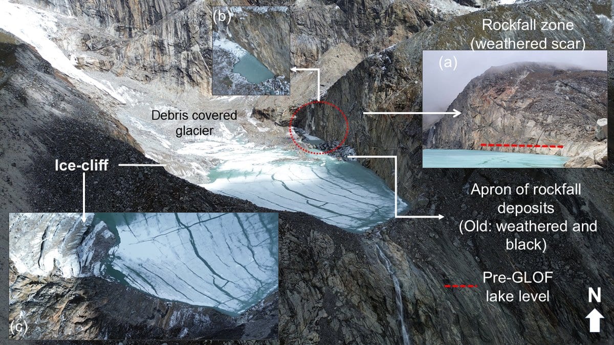
What is not modeled is what set the upper lake off in the first place, and there the authors decline to commit. Their own reading points to a hydrological tipping point: the days before the flood were hotter than almost anything in the local record, with heavy rain on top of them, and that combination would have poured meltwater and calved ice into a lake held back by three or four meters of moraine sitting on bedrock. A field team from ICIMOD that reached the site earlier reported a rockfall into the lake instead. This paper's imagery and field geology do not show one: the boulders along the eastern margin are dark and weathered, and appear in pictures taken years earlier. But the authors keep a rock avalanche on the table as a possible contributor and say the trigger needs more investigation.
The authors would rather move what is in the way
The recommendation the paper ends on is not about the lakes. Damage in the Khumbu Pasang Lhamu rural municipality alone came to about 6.18 million US dollars in settlements, trekking routes, and infrastructure, and the flood's effects were traced more than 50 kilometers downstream. Against that, the authors argue for cutting exposure and vulnerability (land-use zoning, evacuation planning, monitoring of the ground movement now under the village, and over time moving buildings and infrastructure out of the channel) in preference to relying solely on engineered control at the source. The word carrying the weight is "solely." They endorse selective, over-toppable diversion berms and local bank protection near the village. What they reject as the primary answer is large-scale river engineering and expensive works at the lakes themselves.
Both lakes are diminished now. The lower one has lost about 80 percent of its volume and no longer touches a glacier. The upper one is still fed by a calving glacier and still holds a substantial share of its water, though most of the moraine that failed in 2024 is gone, and it now sits largely in bedrock, which makes a repeat of that particular breach less likely. The authors want it monitored, and they want a working early warning system in the valley, on the grounds that the residual risk does not go away. Thame's warning in 2024 was a flat of sand that happened to lie in the right place, and the noise of the water arriving.
Sources
- Natural Hazards and Earth System SciencesPeer-reviewed