Mauna Loa's Eruption Ended Too Abruptly for a Draining Reservoir to Explain

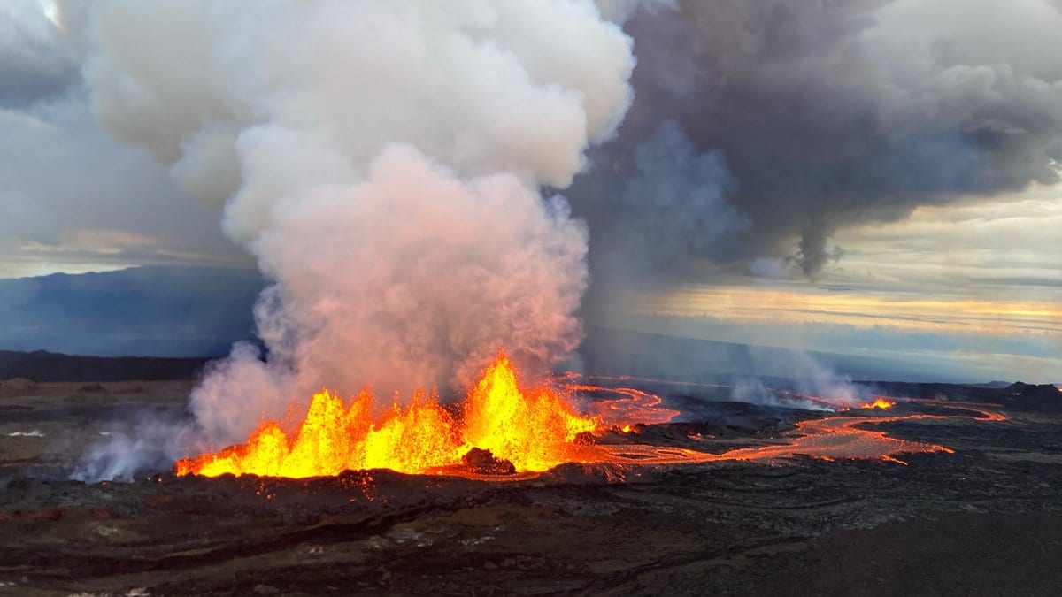
For more than a week, the lava channel below fissure 3, on Mauna Loa's Northeast Rift Zone, had run like a river in flood, fed by fountains throwing rock above the cone they were building. A trail camera on the ground nearby, the kind sold to photograph wildlife, took a short video clip every 15 minutes. Around midday on Dec. 7, 2022, the clips caught the river collapsing. Over roughly four hours, the rate at which lava left the vent fell from about 500 cubic meters a second to about 100, and the eruption that had threatened the main road across the island of Hawaii was finished.
That collapse is the subject of a paper published Nov. 21, 2026, in the Bulletin of Volcanology by Matthew R. Patrick of the USGS Hawaiian Volcano Observatory and seven colleagues at the USGS and the University of Hawaii at Manoa. Their question is not how the eruption began but how it stopped, the harder of the two. The processes that end an eruption, the authors write, are still poorly understood — and they are what an emergency manager needs to know.
The 2022 eruption was Mauna Loa's first in 38 years. It began in the summit caldera late on Nov. 27, 2022, moved into the Northeast Rift Zone within hours, and within a day had focused on one vent, fissure 3, whose flow ran 19 kilometers north. Mapping of the eruption, published separately, put the flow front 2.8 kilometers short of the Daniel K. Inouye Highway, the road across the middle of the island. Nobody was hurt and nothing was destroyed.
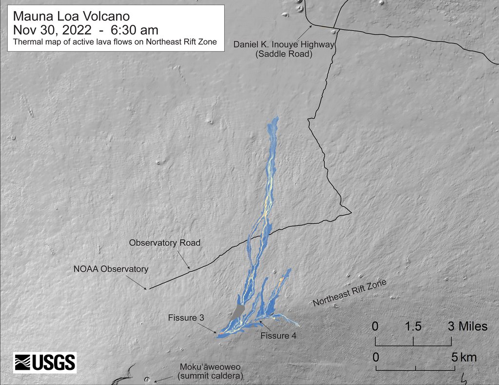
For two weeks, the eruption traced a familiar curve. A model set out in 1981 treats the magma reservoir as a chamber that behaves like a deflating balloon: pressure drives a fast rise to a peak, then an exponential decline as the chamber drains. Seismic tremor, the most complete record of the eruption's vigor, peaked on Nov. 29, 2022, and then declined in just that way. What the model cannot produce is an ending that sharp: a deflating balloon tails off; it does not shut.
The summit started swelling again
At the summit, a tiltmeter in a borehole had been recording the ground tipping toward the magma reservoir, the signature of a chamber losing pressure. Late on Dec. 7, 2022, within hours of the collapse in the channel, the tilt reversed: the summit began to swell. Patrick and colleagues read that turnaround as the moment the rate of lava leaving the vent fell below the rate of magma arriving from depth. The tilt record is public, archived as a USGS data release that one of this paper's authors co-wrote.
What joins the two is a proposal, and the authors mark it as one every time. The pressure of the magma is what holds open the dike, the thin vertical crack that fed the vent; once supply falls below some threshold, they argue, the surrounding rock squeezes it closed, cutting off the last of the flow and backing magma up behind it. The match in timing "leads us to hypothesize" that this is what happened, they write, and their conclusions keep the same verb: "We propose that dike closing was the process, superimposed on reservoir depressurization, that effectively terminated the eruption, akin to a valve in the magmatic pathway." Nobody watched the dike close. The closure is an inference from what instruments at the surface recorded.
The paper also names a rival explanation and declines to close it. A sharp drop in the gas bubbling out of the magma could have lowered the lava column enough to cut off supply. The authors say they favor the mechanical closing, but write that "the role of gas-driven dynamics in controlling the abrupt drop in effusion rate is still an open question." The gas route, they add, would still need a plug of some kind to explain why magma backed up under the summit.
How far did it close? Treating the dike as a flat-sided slot and reading exit speed off the fountain heights, the authors estimate it narrowed over those four hours to a factor of 0.24 to 0.28 of its earlier width, roughly a quarter. That figure is an estimate from a simplified model, not a measurement, and it covers only the main shutdown; the full closure the model ends with is a separate claim.
A trail camera can measure a lava river
The record that caught the collapse came from equipment anyone can buy. The team set white-flash trail cameras beside the channel in video-lapse mode, writing short clips to a memory card. Those clips went through PIVlab, a toolbox that tracks how far patterns shift between frames, which gives the speed of the crust on the lava; with the channel's width and depth, that converts to a rate. The established tools, satellite thermal images and measurements made on foot, give a few numbers a day and "might be too temporally sparse" to catch the start of an abrupt drop, the authors write.
Fountain heights, measured by hand, frame by frame, came from a second camera's stills. They fit: the span of fountaining shrank through the eruption until, by midday on Dec. 8, 2022, it was a single 50-meter patch, while the peak heights, which had been falling all week, jumped to about 150 meters. Taller fountains out of less lava are what a narrowing pipe below the vent does, the authors write. The channel rates were consistent with field and drone measurements made nearby by a companion study, which shares authors and an agency with this one: a cross-check, not an outside one.
The decline curve gives a ceiling, not a date
Abrupt endings are not peculiar to Mauna Loa. One survey of past eruptions found only about a third followed the simple curve, and the authors list several that stopped sharply instead: Fagradalsfjall in Iceland and Cumbre Vieja in the Canaries, both in 2021. The repeated pattern in the ongoing summit eruption of Kīlauea looks the same to them. On that handful of cases, they write, "We suggest that this trend may be common in basaltic eruptions elsewhere" — a suggestion over a short list, not a count of how often it happens.
The practical consequence is in what a forecast can claim. It is tempting to read an eruption's end date off a declining curve; the authors' point is that the curve gives a maximum, because eruptions "can terminate sooner than the decay rate would suggest." Promising more eruption than a volcano delivers, they write, costs an observatory its credibility with the people who must act on it. Their argument is that a valve closing belongs in the uncertainty an observatory hands over, beside the date.
Sources
- Bulletin of VolcanologyPeer-reviewed
- link.springer.com