How Kīlauea Refilled the Hole It Made in 2018

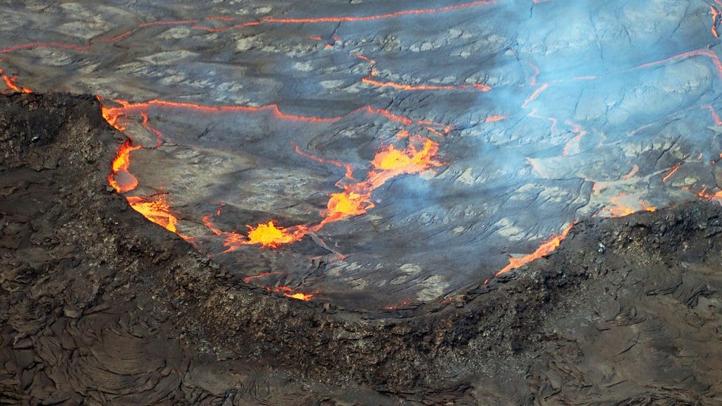
On July 25, 2019, a helicopter crew over Kīlauea's summit spotted water at the bottom of Halemaʻumaʻu. The pit crater had held a lava lake for a decade. Now its floor sat below the water table, groundwater was seeping in, and one of the most active volcanoes on Earth had a pond in it.
Less than a year earlier, Kīlauea had taken itself apart. Lava poured from the volcano's lower East Rift Zone for 120 days, more than a cubic kilometer of it, destroying over 700 structures. At the summit the caldera floor dropped in 62 separate collapse events, each releasing the energy of a magnitude 4.9 to 5.3 earthquake. Those numbers were established by the wave of studies that followed. Then, in August 2018, it all stopped: earthquakes, ground movement and gas emissions fell away together, and Kīlauea went quiet.
What nobody could say was what came next. The authors of a new paper list the questions that hung over the volcano. How long would it stay dormant? Would the amount, the location or the style of its underground magma storage change? Would the next eruptions be explosive ones, able to threaten people, infrastructure and aircraft? Kīlauea answered the first faster than was reasonable to expect: lava was back in the 2018 collapse pit in December 2020.
The five years that followed are sorted into four phases in a paper published Oct. 21, 2026, in Bulletin of Volcanology. Andria P. Ellis, a geophysicist at the U.S. Geological Survey's Hawaiian Volcano Observatory in Hilo, led it. Four of the six authors are at that observatory; Michael P. Poland and Marco Bagnardi are at the USGS Cascades Volcano Observatory in Vancouver, Washington. This is the agency that runs the instruments writing up what its own network recorded, and the paper itself concludes that a broad monitoring network is what made these years legible.
Three kinds of measurement carry most of the story, and none of them involves looking inside the volcano, because nobody can. Tiltmeters sunk into boreholes register the ground near the summit tilting by amounts far too small to feel, as magma pushes in or drains away. Satellite positioning receivers track how far apart two points on the volcano drift. Radar satellites passing overhead produce interferograms, pictures whose colored fringes map how far the ground moved between one pass and the next. Together they stand in for a look underground.
What that record bought is stated in the paper's own carefully bounded words: "In some cases, these observations illuminated parts of the volcano's magmatic system for the first time since the advent of modern geophysical monitoring." In some cases, and parts of it. Several components of Kīlauea's underground network had not moved since before the modern instruments existed, and when they finally did, something was watching.
A hole that filled itself back in
Phase 1 ran from December 2020 to March 2023: long summit eruptions, modest output. The water lake boiled away without any significant explosion when the first of them began, and a lava lake grew in its place. By the time that eruption was declared over in May 2021, it had filled the 2018 collapse pit to a depth of 225 meters. Two more summit eruptions followed, the longer of them stopping in December 2022, a day before Mauna Loa's eruption next door also ended.
Phase 2 was short and different in character: two brief summit eruptions, in June and September 2023, fed faster and with rapid inflation between them. The September one opened a line of fissures running a little over a kilometer east across the caldera floor, into a part of the caldera that had not erupted since 1982.
The year both rift zones switched on
Through 2023, everything since the collapse had happened inside the caldera. In 2024 it stopped being a summit story, which is the part of this record with the most consequence for people who live on the island.
The Southwest Rift Zone is the quieter and shorter of Kīlauea's two rift zones, and it is thinly instrumented. It had not erupted since 1974, which means it had never erupted at all in the era of broadband seismometers, borehole tilt, satellite positioning and radar. In late January 2024 it took magma. More than 3,000 earthquakes were recorded over several days and cracks up to 10 centimeters wide opened southwest of the summit, but no lava appeared.
Because so little of that zone is instrumented on the ground, the scale of what happened only became clear from orbit. A radar satellite happened to image the area on two consecutive evenings during the intrusion, which let the team build an interferogram spanning a single day in the middle of the event. The sequence shows the dike about 5 kilometers down the rift on the first evening and about 10 kilometers by the next, still being fed from the reservoir under Halemaʻumaʻu, with individual strands of the Koaʻe fault system slipping as it passed. That fault belt, a zone of cracks and faults running east from the Southwest Rift Zone to the East Rift Zone south of the summit, had only rarely been seen to respond to an intrusion at all.
On June 3, 2024, magma re-entered that same path and reached the surface. Four fissures opened along about 2 kilometers just southwest of the caldera, the eruption lasted roughly eight and a half hours, and the lava it laid down was mostly less than a meter thick. It was the first eruption in the Southwest Rift Zone since 1974. Hawaiʻi Volcanoes National Park, which covers the ground it happened on, describes it the same way from its own side: the area's first significant activity since 1974.
The small volume belied the scale of what was moving underground. Ground cracking ran for kilometers down the rift, and the single permanent positioning station out there moved more than 20 centimeters to the southwest, with new cracks opening beside it. Radar showed the ground pulled apart along nearly 15 kilometers of rift. Almost none of it made earthquakes. The dike's advance was, in the paper's words, "nearly aseismic", which the authors call "perhaps the most striking aspect" of the June eruption; the magma had most likely re-used the crack it opened in January, producing major deformation and almost no seismicity.
The East Rift Zone followed. Intrusions through that summer ended in an eruption that began on Sept. 15, 2024, just west of and inside Nāpau Crater and ran for five days. Both rift eruptions started almost invisibly. In June the earthquake rate and the tilt had been falling back toward normal for hours by the time lava appeared; the first sign was glow on webcams, including cameras at the astronomical observatories on Mauna Kea, and what park staff and visitors could see. In September it was low-frequency tremor and infrasound, sound below human hearing, that gave the eruption away, with heavy rain and a remote location hiding it from everything else.
Both eruptions broke out where intrusions had already opened a path weeks earlier, so the usual crescendo never came. The authors take two lessons from that. Magma can exploit a pathway it made before, which makes it hard to tell whether an intrusion will reach the surface at all or when. And the traditional signs of an imminent eruption at Kīlauea, earthquake rates and tilt measured from a distance, may be less useful than infrasound for catching what they call a "sneaky" onset.
The most quotable result is the most hedged
The Koaʻe fault system had long been suspected of taking magma now and then, but only from the East Rift Zone side. Reading the radar images from that intrusion, the authors find "a suggestion" that magma "also infiltrated the fault zone from the west". If that is right, an intrusion arriving at the upper part of either rift zone can "back in" to the fault system, moving opposite to the direction a dike would normally travel.
They go one careful step further. "An intriguing possibility is that the rift zones are segmented and have stress barriers", they write, which would at times make the sideways move into the fault zone easier than carrying on down the rift. That interpretation implies "an increased chance of eruption than previously anticipated in those areas" and "could impact lava flow hazards assessments". It is a hypothesis about where eruptions may be possible, in the paper's own conditional language, and not a warning that one is coming.
A second interpretation is about where magma goes when it is not erupting. For long stretches since 2018 the middle East Rift Zone has been contracting and sinking, and the paper calls the cause of that "the unresolved question". Three things could explain it: magma flowing back uphill toward the summit, magma cooling and shrinking, or magma draining downward into the deep rift zone, a poorly understood region several kilometers down. The first two the authors argue are unlikely. "We suggest that downward migration of magma into the deep rift zone is the most likely explanation", they write. The consequence stays conditional: if correct, the recognition that magma can be stored in the rift zone and drain downward out of it is "a critical finding", because the deep rift is the single largest unknown in any accounting of the volcano's magma supply.
What the paper does not resolve is on the record too. The cause of the small deflation and inflation cycles that summit tiltmeters have traced for decades, each lasting hours to days, remains ambiguous. So does the relationship between the two magma reservoirs under the summit, the shallow one beneath Halemaʻumaʻu and the deeper one under the south caldera, which sometimes move together and sometimes in opposition. And the slow slip events on the south flank, quiet earthquake-like slips on the fault the whole flank rides on, have not been seen since the magnitude 6.9 earthquake of May 2018; modeling by one of the paper's co-authors suggests they may not return for decades.
Where Kīlauea is on publication day
The paper's cut-off is August 2026, and it says so plainly: the fountaining of Phase 4 is described as ongoing as of that month. Two months have passed and the volcano has moved on. The observatory's daily update of Oct. 20, 2026, puts it in the past tense. Kīlauea "has been erupting episodically between December 23, 2024, and August 25, 2026", the observatory writes, from two vents in Halemaʻumaʻu, in episodes that generally lasted less than 12 hours and were separated by pauses of two weeks or more. Then came a pause of about seven weeks.
Two of the paper's numbers belong to that closed window rather than to now. The 39 eruptive episodes it counts are the episodes through the end of 2025; the observatory is at 55. And the fountains it describes as regularly exceeding 300 meters are the fountains of 2025 and early 2026.
Episode 55, on Oct. 17, 2026, broke the pattern. It was preceded by 39 days of intermittent overflows, which the observatory calls "a record for the length of precursory activity prior to fountaining". During that long run-up, short-lived vents opened inside Halemaʻumaʻu and, in the observatory's words, "a shallow dike was emplaced beneath Kaluapele", the caldera the crater sits in. Summit tiltmeters recorded more pressurization than usually precedes a fountaining episode, and it arrived in fits rather than steadily. The episode itself lasted just under six hours, with a maximum fountain of about 220 meters from the north vent. Where the paper describes a pair of vents, the observatory now names three. The south one was buried under its own tephra during the episode.
Kīlauea is paused as this is published. The alert level is ADVISORY and the aviation color code YELLOW. Summit tilt turned back to inflation the moment the fountains stopped, and on the strength of that the observatory forecasts the next episode "between October 27 and November 6, 2026". It attaches a caveat to its own forecast: because the run-up to episode 55 was so unlike the others, "there is uncertainty in whether future episodes will return to the regular, predictable patterns that allowed them to be forecast with reasonable precision". Everything erupted since December 2024 has stayed inside a closed area of Hawaiʻi Volcanoes National Park, and the caldera rim around Halemaʻumaʻu has been shut to the public since late 2007.
The question the 2019 pond posed has an answer now. After an eruption that drained the equivalent of more than a decade of magma supply, it was reasonable to expect Kīlauea to stay quiet for many years, perhaps a decade or more. It took about eight months for the summit to start pressurizing and a little over two years to erupt again. The storage zones under the caldera came through the collapse intact. What the five years since suggest, the authors write, is a volcano that is always somewhere "on the continuum between erupting and recharging from an eruption".
Sources
- Bulletin of VolcanologyPeer-reviewed
- www.usgs.gov
- www.usgs.gov