When Several Parts of Europe Burn at Once, the Same Pressure Patterns Keep Showing Up

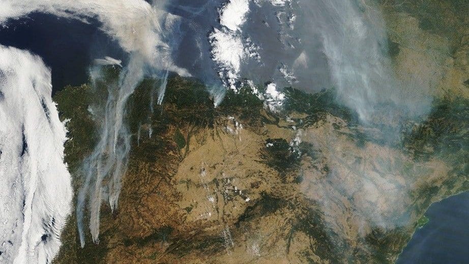
In the summer of 2018 the forests of Sweden burned, and the rest of Europe helped put them out. Germany, France and Italy sent equipment and firefighters north under the European Union Civil Protection Mechanism, the arrangement that shifts firefighting capacity across borders when one member state runs short. It worked because the fire was in one place. The whole arrangement rests on an assumption that is easy to state and hard to plan around: somewhere else is not burning.
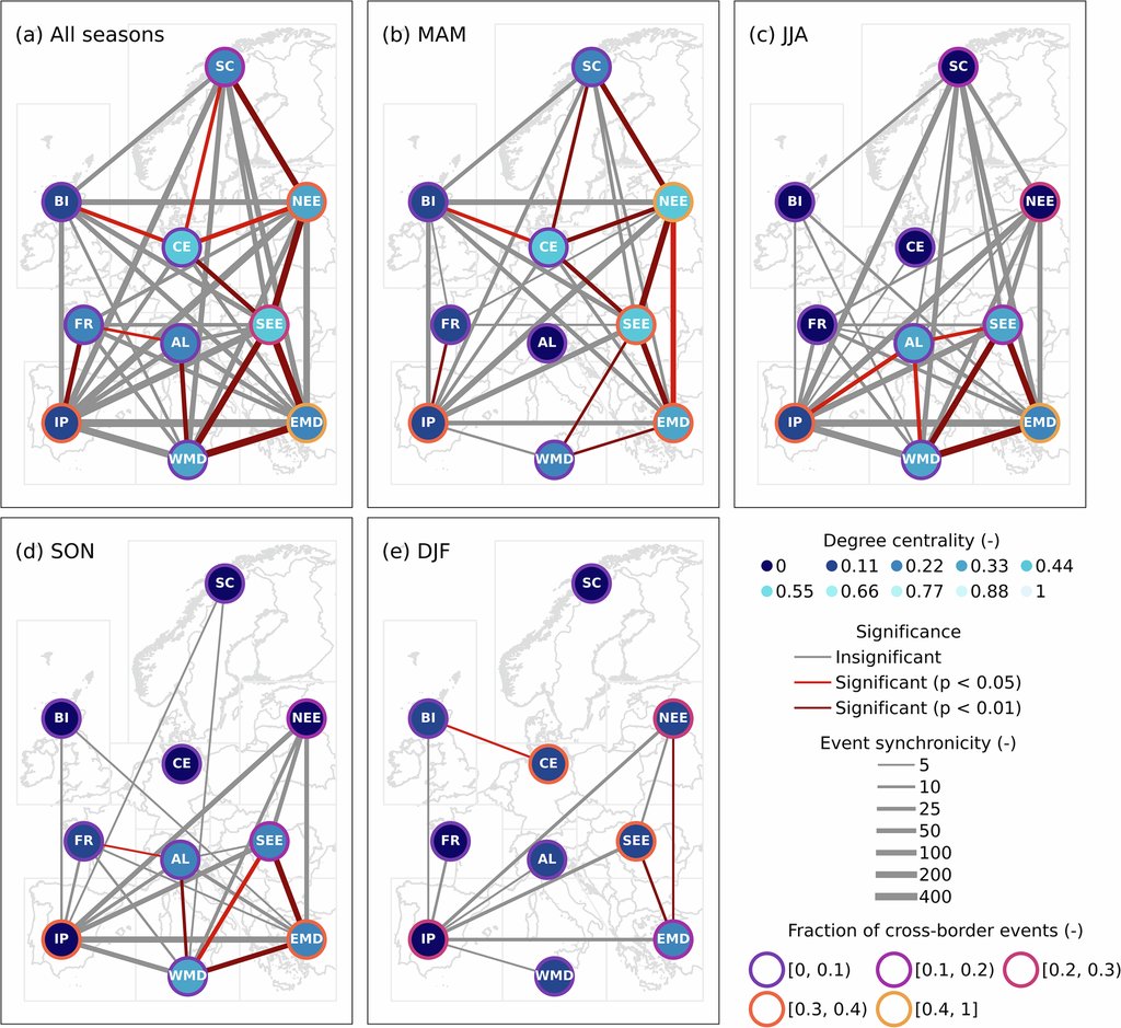
How often that assumption fails is what Xinhang Li, a wildfire researcher at the WSL Institute for Snow and Avalanche Research SLF and at ETH Zurich, set out to measure with Manuela I. Brunner and three colleagues. Working from satellite-recorded fire events across Europe from 2001 to 2020, they sorted the continent into ten regions and counted every occasion on which two of them began burning within six days of each other. Their paper appeared Sept. 17, 2026, in Communications Earth & Environment.
The question is not academic. Extreme fire seasons have become more frequent in Europe over recent decades, and they now reach past the Mediterranean into central and northern countries that used to think of wildfire as somebody else's hazard. Two regions burning in the same week can mean two capitals asking for the same water bomber on the same morning.
A weather regime is a large-scale pressure pattern that settles over the North Atlantic and Europe and then stays, for days or weeks, holding the same sort of weather in place. Forecasters recognize seven of them over this part of the world year-round, some built around high pressure and some around low, among them European Blocking and the Atlantic Ridge. The paper puts one question to each. When this pattern is overhead, are two European regions more likely than usual to be burning at the same time?
The patterns that keep showing up
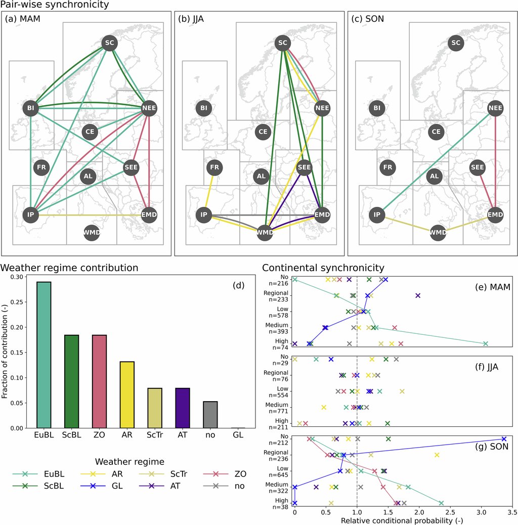
Two answers came back, and they are measurements of different things. The first is about pairs of regions. In summer the Atlantic Ridge, a high parked over the ocean west of Europe, raised the odds for several pairs at once; across the fire seasons as a whole, European Blocking, Scandinavian Blocking and the Zonal Regime contributed the most to regions burning in pairs.
The second answer is about size rather than pairs. In spring and fall, the more regions were alight together, the more often European Blocking was the pattern sitting over the continent, and European Blocking is the regime most likely to be present when more than five of the ten regions burn inside the same week. One pattern pulls the other way. Greenland Blocking leaves low pressure over mainland Europe and brings cold, damp air with it, and in spring and fall its presence went with fewer regions burning at once.
Warm and dry does most of the work
None of this is the atmosphere setting fires. What the patterns deliver is weather, and on days when two or more regions were burning the weather record shows the same signature almost everywhere: temperature above normal, humidity and rainfall below it. Wind is the part that resists a tidy summary. On those days wind ran below its normal strength in Scandinavia, central Europe, the British Isles, France and the Iberian Peninsula, where the stalled highs that matter are calm rather than gusty, and above normal only in the Alps and the western Mediterranean. Wind is a secondary driver here, not a general feature of a week when several regions burn.
Underneath the circulation sits something slower: the calendar. Regions whose fire seasons overlap burn together more often, which sounds obvious and had not been measured for Europe. "While Scandinavia and Southern Europe mainly experience fires in summer, forests in Germany, the UK and Central Europe burn more often in spring," Li said in the institute's announcement of the work. Spring turned out to be the most connected season, with 11 significant links between regions; winter had the fewest.
The novelty claim here is narrow, and the authors keep it narrow. Fire-danger indices and climate models have looked at synchronous fire weather in Europe before, and have projected more of it as the climate warms. This paper is about synchronous fires: the events themselves, as satellites recorded them. "Yet, to the best of our knowledge, observation-based evidence of synchronous wildfire occurrences across Europe does not exist," the authors write of the gap they set out to fill.
Two independent lines of work support the mechanism without testing the new result. Bui and colleagues reported in 2022 that standing waves in the summer jet stream synchronize wildfire occurrence across the Northern Hemisphere. Little and colleagues found in 2025 that spells of persistent high pressure go with heightened wildfire activity across Europe. Both are about pressure that sits still, and neither counts how often distant European regions burn in the same week. That count is this paper's own, and it rests on this paper alone.
Why a forecast might see it coming
The reason any of this could reach a control room is that the patterns are easier to forecast than the weather they produce. They are more predictable on subseasonal timescales, several weeks in advance, than local daily conditions are, and the paper offers that as a prospect rather than a product: its findings "could support early warning systems" for synchronous wildfire emergencies in Europe. No such system exists, and the paper puts no figure on the lead time beyond "several weeks." What it hands a civil protection planner now is a season-by-season map of which region pairs tend to burn together, and under which pattern.
The limits sit in the data as much as in the method. "From space, you can only see forest fires once they're large enough," Li said; the analysis keeps only fires above 18.75 hectares, drops cropland burns, and cannot say what lit any of them. The record ends in 2020. The paper allows that these events "may become more frequent in a warming world" and marks that as a suggestion, not something it computes. The fire catalog, the weather-pattern classification and the Python behind every figure are posted publicly, so another group can take the same record apart a different way.