China Checks for Dam-Triggered Quakes Within 10 Kilometers. The Quakes Go Farther

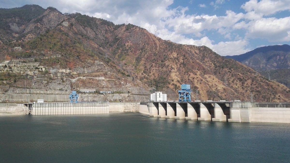
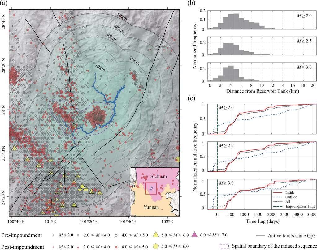
The valley of the Yalong River in western Sichuan began to fill behind the Jinping-I dam in November 2012. Within a year, two knots of small earthquakes had appeared near the new shoreline. None of that was a surprise in itself. A deep new lake can wake the faults underneath it, and one of the textbook cases, the Xinfengjiang reservoir in Guangdong, is Chinese. The harder question is how far from the water a planner needs to look.
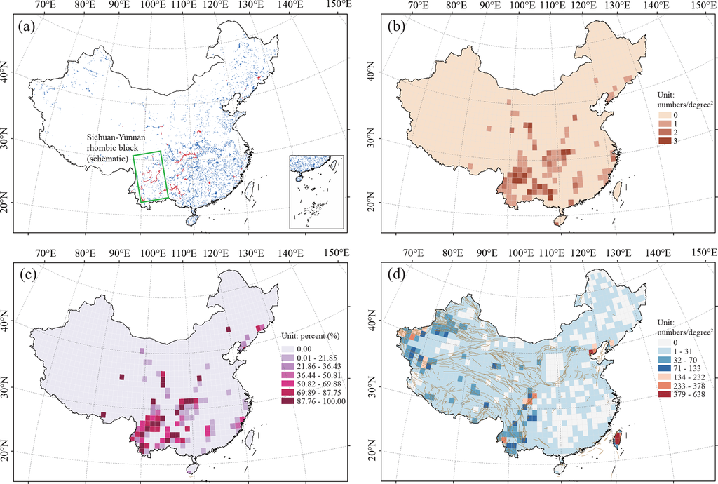
Six researchers at the Institute of Geophysics of the China Earthquake Administration, with a seventh at the Tianjin Earthquake Agency, have now put a national figure on it. In a paper published Nov. 11, 2026, in Natural Hazards and Earth System Sciences, Jiashan Zhang, Changsheng Jiang and their colleagues screened 1,435 of China's large and medium reservoirs against the national earthquake catalog, kept since 1970 by the China Earthquake Networks Center. Eighty-eight of those reservoirs, they report, sit under a burst of seismicity that clusters in space and time around the first filling of the lake.
The point of that count is a number in a rulebook. China's standard for this hazard, GB/T 21075-2007, uses a dam's height and a reservoir's capacity to decide which projects need an assessment, and then draws the assessed area as the reservoir plus a ring 10 km wide. Set against the 88 sequences, that ring is too tight. Ninety-five percent of their earthquakes fell within 24.8 km of the shoreline, and 99% within 38.2 km. Those distances describe the earthquakes of the 88 identified sequences over the 10 years after filling, not all seismicity near Chinese reservoirs.
The ground decides, not the dam
The 88 are not spread evenly. They crowd into the tectonically busy southwest, above all the Sichuan-Yunnan block along the eastern margin of the Tibetan Plateau, where faults have moved in the recent geological past and moderate earthquakes are routine. The flat, stable east of the country is thick with reservoirs and almost never produces an induced sequence. Canadian reservoirs, in old and stable crust, keep their induced earthquakes within a few kilometers of the shore. Tectonics, not engineering, decides whether a new lake sets anything off.
That list was built by eye. The authors set aside the automatic clustering algorithms seismologists usually reach for and worked through every candidate themselves. The test had three steps: a sharp and lasting rise in earthquakes after the filling; a tight cluster hugging the shoreline rather than a smear along a regional fault; and the two coinciding in the same patch of ground. So the 88 are reservoirs whose seismicity clustered around the filling, not 88 individually confirmed cases. Telling a human-caused earthquake from one the ground would have produced anyway is the hard part of this subject everywhere; in Texas it has taken a fault-by-fault physics test to apportion blame between wastewater disposal and fracking.
How far the water reaches is an inference
Both the timing and the spread point at a well-established mechanism: water works down through fractures and faults, raises the pressure in the pores of the rock and loosens faults already close to slipping. Seismicity peaks one to two years after filling and thins out steeply with distance from the shore.
The sequences carry a statistical signature too. Induced ones have a higher b-value than natural ones, meaning more small shocks for each large one. They also have a lower alpha-value, meaning one shock is less likely to set off others. Both differences are significant; a third measure, how fast a sequence dies away, is not (P = 0.461). That comparison uses the 38 of the 88 sequences with enough earthquakes to fit, against 66 natural sequences taken from earlier studies rather than reanalyzed here.
The distance comes out of that same b-value. The team compared each induced sequence's b-value against that of ordinary background seismicity at increasing distances from the shore. As the team widened the circle in steps, the difference turned significant once the circle reached 30 and then 40 km, and lost its significance past 40 km, where, the authors argue, reservoir water stops mattering and regional tectonics take over. That distance, they write, "may be a critical physical boundary." The same figure carries the other version of the test, run in separate rings, and that one finds no significant difference in any ring; the authors put it down to too few earthquakes far from the shore. So 30 to 40 km is an inference these authors draw from one test, not a distance anyone has measured.
No dam measurement predicts the magnitude
Does a bigger reservoir make a bigger earthquake? Barely. Across the 88, five fixed properties all correlate positively with the largest magnitude in the sequence: capacity, dam height, surface area, average depth and the length of the long axis. The correlations are weak, and for each property at least one of the two standard measures is significant. The values run from 0.20 to 0.28 on Pearson's r and from 0.21 to 0.32 on Spearman's rank coefficient. Three measures of how a sequence behaved, among them how long after filling the peak arrived, come out at essentially zero. The conclusion is narrower than a flat claim that size does not matter: no single reservoir measurement reliably predicts the largest magnitude on its own, which the authors put down to the faults already in the ground, their size and how close to failure they already were.
What size does predict, a little, is whether anything happens at all. Above a capacity of about 320 million cubic meters, and above a long axis of 15.9 km, the share of reservoirs that turned out to be induced-type rises well above the roughly one in 16 of the whole sample. The authors offer those two as rough screens at the planning stage, a different question from how large an earthquake would be.
Their recommendation, and it is a recommendation rather than anything under way, is that the assessment and monitoring range be widened from 10 km to the 30 to 40 km boundary they infer. The Institute of Geophysics belongs to the same China Earthquake Administration whose standard the paper calls too narrow, and the authors declare no competing interests. They are equally plain about the model's main simplification, which treats the whole country as behaving alike and "inherently neglects regional variations in crustal permeability, stress regime, and lithology." The earthquake catalog underneath all of it is proprietary and, they write, cannot be released.
The usable part of the paper is narrower than its headline distance, and firmer: the southwest is where this happens, and a dam's own dimensions will not tell anyone how hard the ground will shake.