Nobody Was Watching This Volcano. An Ocean Away, Something Heard It.

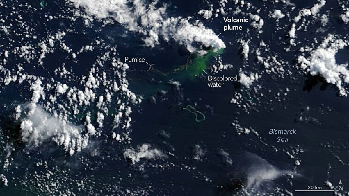
The sea off Wake Island had been quiet since May 6, 2026. Two triads of hydrophones, moored in the sound channel that carries noise across whole ocean basins, were picking up nothing but ambient water. Then, at 08:04 UTC on May 8, 2026, they began recording coherent arrivals from a steady bearing to the southwest, and they kept recording them for most of a day. The source lay 3,159 kilometers away, on a ridge in the Bismarck Sea that no local instrument was watching. A vent on the Titan Ridges, off Papua New Guinea, had started to erupt.
Thirteen researchers led by Simon Plank of the German Aerospace Center have now set that sound record beside regional earthquake data and thermal, optical and radar satellite imagery to reconstruct the eruption's first three weeks. Their paper, published Oct. 31, 2026, in Bulletin of Volcanology, is open access. The reason: by volume, roughly 70 to 80 percent of Earth's volcanic activity happens underwater, and most submarine eruptions in the published record produced nothing at the sea surface that anyone saw.
The chronology three systems built together
Coherent sound began at 08:04 UTC. The first regional seismic detection followed 17 minutes later. The largest earthquake of that opening day, a magnitude 5.6 at 12:22:31 UTC, arrived about four hours after the sound did, and the largest shock of the whole sequence came later, a magnitude 5.7 on May 22, 2026. The first sign of the eruption any satellite could see, a mid-infrared hot spot in Himawari-9 imagery, did not appear until May 9, 2026, roughly 17 hours after the hydrophones.
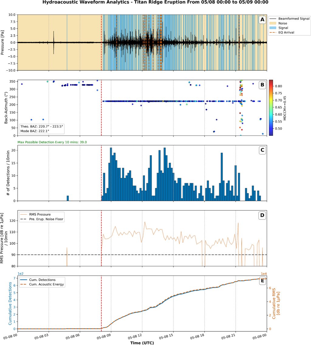
That 17-minute lead needs its qualifier. It is a lead over the first regional detection of the May 8, 2026, onset, made by a detector the team built for this eruption, not over the first seismic signal of the episode. Permanent coverage in the Bismarck Sea is too sparse to locate small low-frequency events, so Plank and colleagues used the ratio between low-frequency amplitudes at the two nearest stations, on Manus Island and at Rabaul, as a trigger. It locates nothing, and the paper says it "does not provide a complete event catalog." The same detector, run back through April, finds possible precursors as early as April 25, 2026.
The 17-hour gap between sound and satellite is the part the authors argue is physical rather than instrumental. Buoyant fragments leaving a vent 400 to 700 meters down reach the surface in under half an hour, so transport does not explain it. Himawari-9 sits in geostationary orbit and images the area about every 10 minutes, so a gap between passes does not either. The paper leaves two readings open: an opening phase that was loud underwater but shed almost no floating material, or an early surface heat flux too faint to register in an infrared pixel 2 kilometers across.
The array fixed the clock, not the place
What the hydrophones could not do shaped the result as much. At 3,159 kilometers, the small difference between the measured bearing and the true great-circle bearing works out to about 45 kilometers across the line of sight, wider than the patch of seafloor the earthquakes were scattered over, and a single triplet of hydrophones gives no distance at all. The sound fixed the timing and the radiated energy, and it could not place the vent or separate it from an earthquake epicenter.
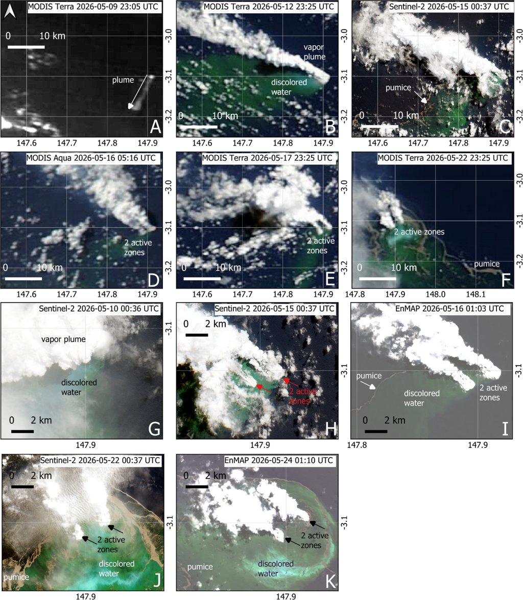
The satellites did that part. Radar and optical images resolved two circles of disturbed water about 2.5 kilometers apart, and a rising plume is pushed sideways by currents, so a patch at the surface is not a vent beneath it. A plume cannot rise more slowly than the pumice it carries, though, and that holds the offset under a kilometer. Two features that far apart therefore sit above two separate vents. Over the three weeks, the western zone held its place while the eastern one tracked about 900 meters north and then split in two on May 29, 2026, which the team reads as a multi-vent system propagating along a rift structure.
The same combination separates the earthquakes from the eruption. Waveform modeling at the two regional stations fits reverse faulting rather than an explosion radiating equally in all directions, so the big shocks were tectonic, plausibly on a known regional fault zone. And the cataloged earthquakes of May 8, 2026, account for only about an hour of the roughly ten hours of coherent sound that day, so something at the seafloor was making noise continuously: gas-driven bursts, lava meeting seawater, or both.
What is left for a ship to find
Size is where the numbers thin out. Two cloud-free Sentinel-2 views let the team map the pumice rafts by how densely they covered the water and convert the areas into a dense-rock-equivalent volume, the volume the fragments would occupy with their bubbles squeezed out: at least 0.011 to 0.014 cubic kilometers. That is a floor, not an estimate. It counts only the fraction that floated, on two days out of three weeks.
Depth is what turns the observations into a prediction. Models of magma rising to a vent put the switch from flowing to blasting apart at roughly 200 to 290 meters of water for silica-rich magma, so a vent at 400 to 700 meters is too deep to shatter its magma on the way up at anything like the discharge the rafts imply. Depth alone, to first order, predicts a quiet, flowing eruption before any observation arrives. So the authors hypothesize what should be down there: a lava flow or a dome, built over the weeks the vents were active. They write it as a model to be confirmed or falsified, and the test is new depth soundings differenced against the old ones.
Two unknowns sit under that hypothesis. The 400 to 700 meters is a pre-eruption figure, read from depth soundings collected between 2007 and 2009 beneath the places where the surface features later appeared, not measured at the vent. And the composition is not pinned down: no fresh magma fragments have been recovered from this eruption or from a 1972 eruption nearby, so the silica-rich thresholds rest on the abundance of floating pumice alone, and basaltic eruptions can float their fragments too.
The seismic anchor is checkable: the USGS catalog lists that magnitude 5.6, and no earthquake at all on May 8, 2026, before 09:23 UTC. The acoustic onset and the 17-hour lag are this team's own measurements from one array. And the eruption is not a closed story. Discolored water was still showing over the site in satellite images through August 2026, and the only way to learn what was built down there is to go and look.
Sources
- Bulletin of VolcanologyPeer-reviewed
- earthquake.usgs.gov