Sensors on a Planned Pacific Cable Would Feel the Earthquake an Hour Before the Wave

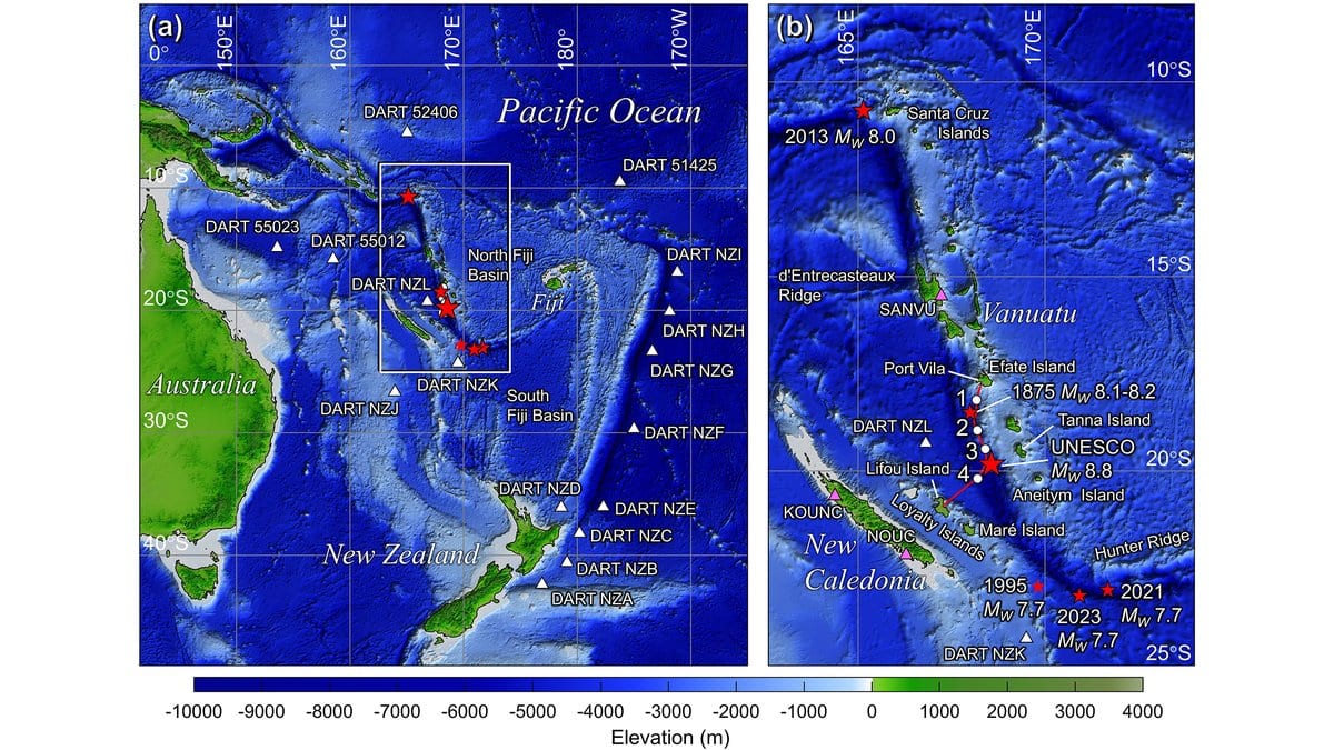
If built as currently drawn, a fiber-optic cable will leave Port Vila, the capital of Vanuatu, and run south along the archipelago. It will cross a trench several kilometers deep and come ashore on Lifou Island, in New Caledonia. Its paying job is phone calls and internet traffic. Four modules spliced into its length will do something else: record temperature, water pressure and ground motion on the seafloor, continuously, in a stretch of ocean where almost nothing is measured at all.
Cables with instruments built in have a name: Science Monitoring And Reliable Telecommunications, or SMART. Several are underway, among them a demonstration project off Sicily and a ring linking Lisbon to the Azores and Madeira. The one planned between Vanuatu and New Caledonia is called TamTam, and it is still early: the route and the four sensor positions are preliminary and subject to revision after the marine survey.
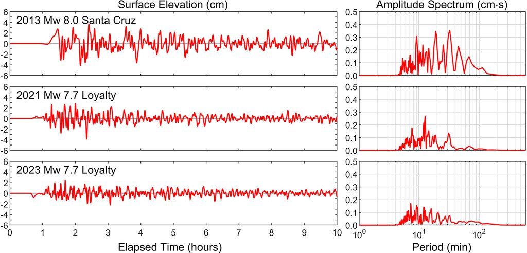
That early stage is the point. Kwok Fai Cheung and Bruce M. Howe of the University of Hawaii at Manoa, Thorne Lay of the University of California Santa Cruz and three colleagues modeled what those modules would have recorded in three earthquakes that really happened and in one that has not. Their results appeared Nov. 19, 2026, in Natural Hazards and Earth System Sciences, and they amount to a set of synthetic traces: the shaking and the waves a sensor at each planned position should expect to see, worked out before anything is on the seabed.
Two clocks run in each of those simulations, and they run at very different speeds.
The fast one is the rock. Take an earthquake at either far end of the Vanuatu subduction zone, where one plate dives beneath another: the magnitude 8.0 Santa Cruz Islands earthquake of 2013 to the north, or one of two magnitude 7.7 earthquakes southeast of the Loyalty Islands. The first P wave, the fastest seismic pulse, reaches the cable about 75 to 120 seconds after the rupture begins, which is when a real-time system could start work. The larger surface waves follow within a few minutes, and with them a first estimate of how big the event was.
The slow one is the water. Each of those three tsunamis takes about an hour to reach the planned route, which the authors call limited time to respond if the wave is judged destructive. An hour of notice is worth a great deal — and it exists only because the earthquake was hundreds of kilometers away.
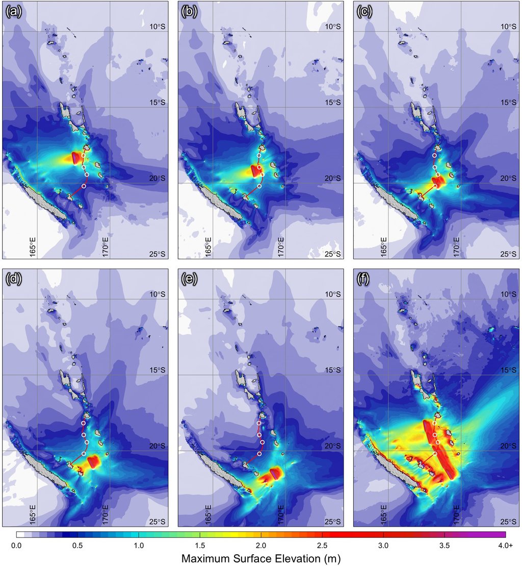
When the rupture is next door, the second clock almost catches the first. The study's worst case comes from a UNESCO expert meeting held in Port Vila in May 2024, which proposed the largest earthquakes it judged possible along the Vanuatu arc. For the long southern segment the cable would cross, that is a magnitude 8.8 rupture, assembled in the model from five separate failures that can also be set off one at a time. For two of them, the tsunami reaches the nearest sensor in 11 and 18 minutes.
Rupture that whole segment at once and the model pushes water up to 11.5 m at Tanna Island and 12.7 m at Lifou, with similar heights along the main island of New Caledonia. Those are sea-surface heights near the coast, resolved on a grid about 0.9 km across. The authors are careful to separate them from runup — the height water actually climbs ashore, which could be larger or smaller depending on the shape of the land. The scenario has not occurred. The closest thing to it in the record is an earthquake in 1875 that left tsunami deposits 10 m above the sea on the northeastern coast of Lifou.
This leads to the least comfortable result in the paper, and the one an operator most needs. For three of the five scenario failures, at least one sensor sits inside the rupture itself. A pressure gauge on the seafloor infers the sea surface from the weight of water above it. Lift the seafloor it rests on, as an earthquake does, and the gauge rises with it; the record is then no longer a clean measure of the wave. Those readings have to be corrected for that uplift before they can be read as wave height at all. The authors add that no seismic station operates near the route to calibrate how ground motion travels there, and they call their traces first-order guidance, not predictions; the short-period shaking at the sensor sites is still unconstrained.
Where the modules sit matters as much as what is in them. The tsunami modeling shows the sea around the Vanuatu Trench ringing in standing waves with periods from a few minutes to more than an hour, their pattern set by the shape of the ridges and island chains, not by the earthquake. The four preliminary positions fall outside the loudest of those patterns, seaward of the island shelves, where the computed wave heights are an order of magnitude smaller than over the shelves themselves. A sensor in a quiet place records something close to the source; a sensor in a loud one mostly records the local ringing.
Until the cable exists, the synthetic traces are the product. Ifremer, the French marine research institute, is to archive the sensor data and pass it quickly to hazard agencies. One of them is the Vanuatu Meteorology and Geo-hazards Department, whose own seismic stations and tide gauges do not reach past the country's coastal waters. Its planners can now rehearse against modeled signals from an earthquake that has not happened. They also know what the cable could not have done. The authors make the limit concrete: a deadly magnitude 7.3 earthquake struck just west of Port Vila on Dec. 17, 2024, too close to shore for any offshore instrument to have bought time. For a local earthquake, the warning is the shaking itself.