Myanmar's Fault Twists With Depth, and Older Satellite Data Already Said So

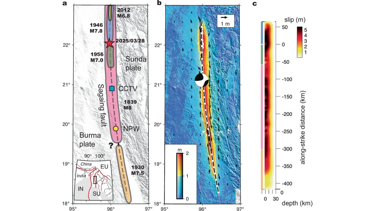
Seismologists have one answer they cannot give, and they give it constantly: nobody knows when a fault will break. So a team working across Munich, San Diego, Zurich and Yangon asked a narrower question of Myanmar's Sagaing Fault, and asked it with the answer already in hand. How much of the earthquake that tore 480 kilometers of that fault open in 2025 was already sitting in satellite measurements taken before it happened?
Quite a lot, as it turns out. Just not the part anyone would most want.
The earthquake struck on March 28, 2025, near Mandalay. The U.S. Geological Survey, whose event record is the authority here, puts the moment magnitude at 7.7. The new study's own model of how the fault moved gives an equivalent 7.81, and the paper, like other work on this rupture published in Science, calls the event M7.8. Shaking reached intensity IX around Naypyidaw and Mandalay. The United Nations humanitarian agency counted more than 3,500 dead in its first situation report, on April 7, 2025.
Nobody predicted it, and the authors of the new paper go out of their way to say so. Their study, published Oct. 14, 2026, in Nature Communications, opens by describing earthquakes as notoriously unpredictable and citing, as its very first reference, a 1997 paper in Science titled "Earthquakes cannot be predicted." The manuscript reached the journal in March 2026, a year after the shaking.
So this is a retrospective study in the plainest sense. The information was in the record beforehand; the reading of it was done afterward, by people who already knew what had happened.
The fault turned out to be twisted
The clearest of the pre-event signals is a shape. Thomas Ulrich of Ludwig Maximilian University of Munich, Xiaoyu Zou of Scripps Institution of Oceanography and colleagues mapped the ground displacement from radar and optical satellite imagery and found that the two sides of the rupture did not match: the east side moved more at the northern end, and the imbalance reversed going south. They worked through the alternatives, including a stiffness contrast across the fault, and none fit. What was left was a fault that does not stand straight up. Testing the tilt section by section gave a northern stretch leaning east, a middle stretch close to vertical and a southern stretch leaning west, a shape the authors describe as a helix.
The twist matters because the same lopsided pattern had already been measured in the slow strain that builds on a locked fault between earthquakes, and published before 2025. The buried shape of the Sagaing Fault was legible in data collected while the fault was still intact. That is worth knowing in advance: shaking is expected to be much stronger on the overhanging side of a tilted fault, which decides who gets the worst of it.
A floor under the slip, and nothing about the clock
The second quantity that was legible beforehand is slip, and it arrives with its limits attached. The idea goes back to a 1980 recurrence model by Shimazaki and Nakata: if a fault stores strain steadily, what it releases should relate to how long it has been storing. The team compared the average slip on four sections of the 2025 rupture with the strain each had banked since its own last large earthquake.
Two of the four matched. The other two released more than they had banked. The uncertainties around that comparison are wide: the fault's two sides slide past each other at roughly two centimeters a year, known to within a few millimeters; the depth to which it is locked is pinned only to within about six kilometers; and two published reconstructions of where the 1946 and 1956 ruptures ended disagree by as much as 50 kilometers. What survives all that is an inequality, not a value. Slip equaled or exceeded the accumulated deficit, which is what the paper calls a "minimally slip-predictable" fault, and the usable form of the claim is a floor: the strain a mature fault has stored tells you the least that a maximum-size earthquake there could release.
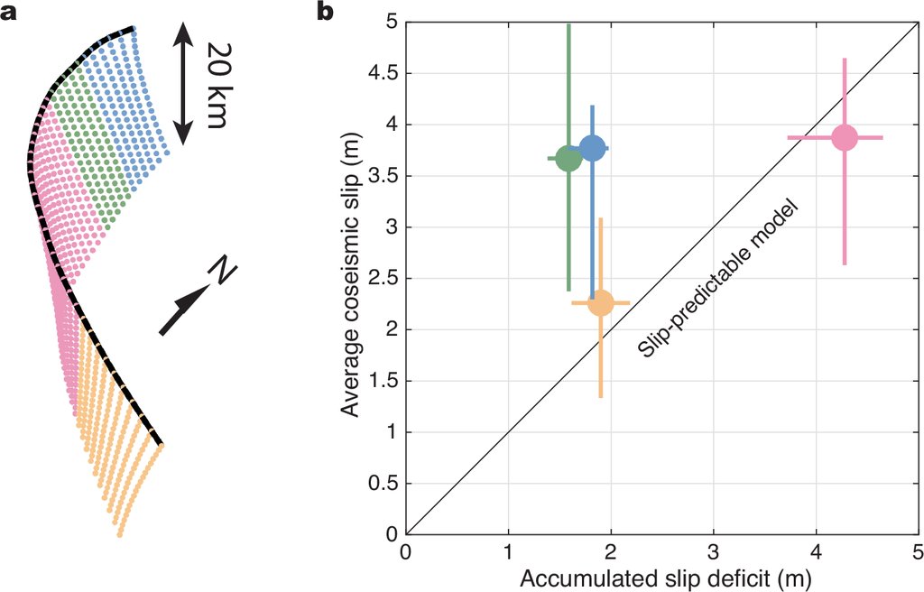
Mandalay is the second case of this, not the first. The pattern was reported for the 2023 Kahramanmaraş earthquakes in Türkiye, which a 2025 study found to be loosely slip-predictable, and the Sagaing rupture follows it. What none of this does is start a clock. "The slip deficit may provide a lower bound on slip in a future maximum-size earthquake, but it does not determine when such an earthquake will occur," wrote Alice-Agnes Gabriel, the paper's corresponding author, in a post for Springer Nature's research communities on Oct. 15, 2026.
Speed was the part that needed the aftermath
Speed is where the paper's title reaches past its own conclusion. The title names slip, geometry and speed; the conclusion names the geometry and the slip pattern, and drops the speed. The reason lies in how the speed was obtained. The team generated 180 simulated ruptures, each anchored to a slip model derived from satellite measurements taken after the earthquake, then narrowed the field with records that also only existed afterward: seismometer arrays on three continents, a strong-motion station close to the fault, and footage from a CCTV camera that caught the ground as it tore.
The scenario that came out of that filtering starts in both directions, then runs south at depth faster than shear waves travel in the surrounding rock, a regime called supershear, while the shallow part of the fault lags behind at ordinary speed and is dragged along by it. The arrival time at the near-fault station implies an average of 4.9 kilometers per second. None of that is this paper's discovery. Independent groups established the supershear character of this rupture from separate data in 2025 and 2026, among them a study in Science, and the authors write that their own preferred scenario, one of the 180, is not unique.
What the pre-event data did supply here is narrower: the helix geometry constrains the conditions under which a sustained supershear rupture is possible. Conditions, not speed.
The two things the paper offers going forward point at opposite kinds of fault, and they are easy to run together. The modeling approach is pitched at sparsely instrumented fault systems, where almost nothing is recorded. The slip-deficit floor is pitched at mature, well-instrumented ones, where the strain has actually been measured for years, such as the North Anatolian Fault near Istanbul and the southern San Andreas. How far either relationship carries into other tectonic settings, Gabriel wrote, remains to be tested.
For hazard, the implication is uncomfortable, and the paper leaves it open. If a single earthquake can cascade through several fault segments at once, estimates built on short historical and paleoseismic records may underpredict what a fault system can do. A longer quiet means more stored strain and so a larger possible earthquake; whether it also makes one likelier, the authors write, remains unclear.