Eighteen Earthquakes That Have Not Happened, on a Fault Still Being Mapped

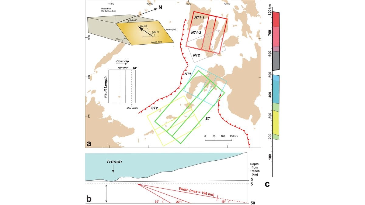
There is a standard reference model of the world's subduction zones, and it includes every Philippine trench but one. The Negros-Sulu Trench is the gap. Seismic surveys have imaged pieces of the slab sinking beneath the Sulu Sea, but not well enough to fix how steeply it tilts, and the onshore GPS network that would show which patches are locked and loading is thin there.
That is an uncomfortable gap, because the fault is big enough to produce a great earthquake. On Oct. 14, 2026, Lyndon P. Nawanao Jr. and Noelynna T. Ramos of the University of the Philippines Diliman and colleagues published a seismic and tsunami hazard assessment of the Negros-Sulu megathrust in Natural Hazards and Earth System Sciences. The method is the interesting part. When you cannot pin a fault down, you model every version of it you can defend.
They cut the subduction zone into pieces where the seafloor ridge above it changes direction, giving six candidate rupture lengths, split between the two trenches. The tilt of the fault was harder. Tomography of the shallow slab points to a gentle angle; the earthquakes recorded along it imply dips as steep as 90 degrees. Rather than choose, the team built each segment three times over, at 10, 20 and 30 degrees, then converted each fault plane's area into a magnitude and an average slip with standard scaling relations. Eighteen scenarios, magnitude 8.0 to 8.9.
Each of the 18 ruptures then went into JAGURS, an open-source tsunami code that accounts for the sideways shove the seafloor gives the water as well as the vertical one. Along the shoreline the authors placed 6,879 sampling points, and recorded at each the highest wave the model produced, the fastest flow and the earliest arrival of the water.
Where the water goes first
The finding the authors put first is about a simpler geometry than the fault's: which way a coast faces. Across all the scenarios the biggest modeled waves land on the shorelines pointed straight at the rupture, in Sipalay-Bayawan on Negros, Sindangan-Labason and Siocon-Sibuco on the Zamboanga peninsula, Basilan-Sulu and the Moro Gulf. Everywhere else the water arrives smaller, after bending and spreading have taken energy out of it. Of those points, 8 percent reach 2 meters or more. Most of the coast in these models does not.
The largest value anywhere in the set is 8 meters, with flow at 6 meters per second, and it belongs to one case: a rupture of the long combined Sulu Trench segment at the middle dip angle, arriving at Sindangan-Labason. Ruptures of the Negros Trench peak near 6 meters somewhere on the coast across that trench's own scenarios, with flow up to 7 meters per second. All of these are wave heights at the shoreline produced by ruptures of each trench, not heights out above the trench itself.
They stop at the waterline. No inundation was modeled: the fine-grained nearshore depth data that would carry the waves onto land does not exist for these coasts, and the computing time was out of reach. So the paper says nothing about how deep water would stand on land or how far inland it would reach; site-specific inundation modeling is listed as the next job.
Arrival time is where the modeling bites. In the majority of the directly facing regions, the earliest wave in the scenario set reaches the coast in under two minutes. That is a minimum across the whole set rather than an expectation, and it is strictly local: for coasts set at an angle to the fault or sheltered behind an island, the same ruptures take anything from 10 minutes to about two hours, the far end of that being northeast Borneo.
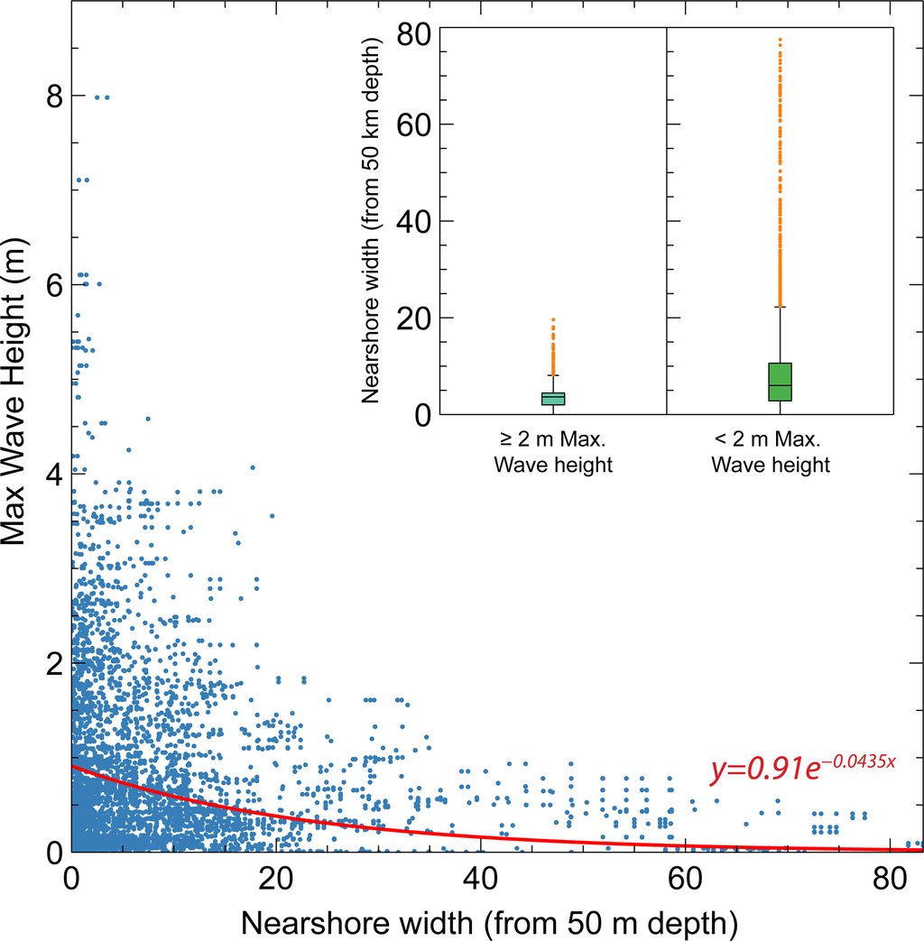
Direction decides first; shape modulates. Coasts that saw 2 meters or more tend to be concave, scooped inward, with a narrow shallow shelf in front of them; a wide shelf drains a wave's energy before it lands, and no sampled coast fronted by a broad shallow shelf reached 2 meters. Outer islands act as a barrier for the ones behind them, bending the waves and taking the edge off. Bays do the opposite: a wave that matches a bay's own rhythm gets amplified, which is how some interior shorelines get a wave at all.
The only check available is the past
A model of an earthquake that has not happened cannot be checked against it, so the authors check it against the ones that have. Eyewitness accounts of the 1897 Sulu Trench earthquake describe waves of about 2 meters across most of the basin and up to 6 meters around Basilan and Sulu; the model's highest wave for that area is 5.4 meters, slightly lower. In most other regions the modeled waves come out slightly higher than what witnesses described. In the Moro Gulf, where the recorded tsunamis all came from the neighboring Cotabato Trench, a Sulu Trench rupture in the model lands inside the range those events left behind, which is the paper's argument that the gulf has a second subduction zone to reckon with. Those accounts are uneven, and the authors say that magnitude may be too low.
No probability, no date
Nothing has ruptured on the Negros-Sulu megathrust, and the paper contains no forecast of when anything will. There is no probability in it, no recurrence interval and no window of time. The only timescale it offers runs the other way: megathrust earthquakes appear to recur over hundreds to thousands of years, and the magnitude-frequency relationship used here rests on 7 catalogued earthquakes for Negros and 21 for Sulu, a thin basis the authors flag themselves. The abstract's opening sentence does say the megathrust "poses an imminent threat to coastal communities surrounding the Sulu Sea"; that is the authors' reading of an unquantified hazard, not a prediction with a date on it.
The biggest weakness is in the slip. Each scenario spreads an average amount of slip evenly across its segment, and real ruptures are lumpy, so the authors recommend reading every height and speed as a minimum value. They are even-handed about which way it errs: slip concentrated near the trench would displace more water than the uniform case, slip bunched deep would displace less. Ruptures that tear through the seafloor at the trench, and faults branching off the main plane, were not modeled at all, nor was the varying roughness of the coast.
What the work hands over is not a warning but a ranking: regional maps of minimum arrival time, maximum wave height and flow speed for coasts that had none, for the offices that plan evacuation routes and decide where seawalls and offshore breakwaters are worth building. The authors point at the same coasts as the best places to dig for sand left by prehistoric tsunamis, which is the only way a catalogue that thin gets longer.
Sources
- Natural Hazards and Earth System SciencesPeer-reviewed