A Landslide Can Turn the Wet Valley Floor Beneath It to Liquid

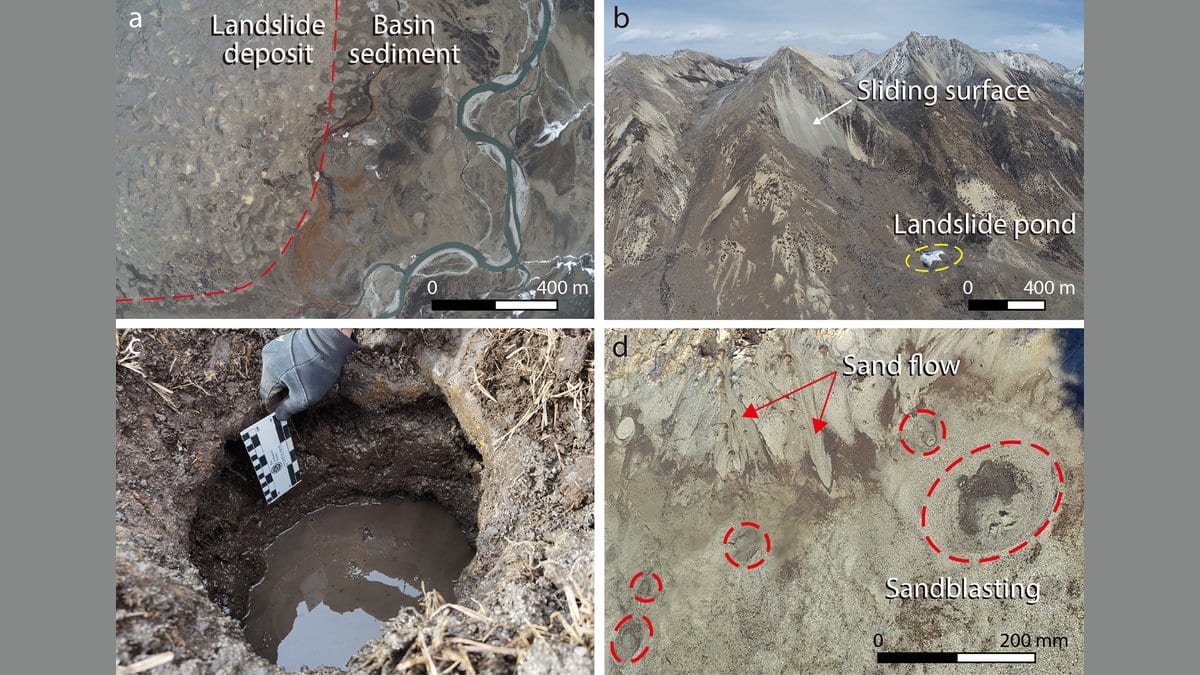
Dig through the thin turf on the floor of the Maoyaba Basin, high on the southeastern edge of the Tibetan Plateau, and groundwater is there almost at once. Along the front of the huge landslide deposit nearby, the sediment is pocked with small craters where pressurized water has blown fine sand up through the surface. None of it looks dramatic. It is, a team of Chinese and British researchers argue, the best surviving clue to why this landslide traveled as far as it did.
The slide is prehistoric. Earlier dating work places it around 3,300 years ago, long before anyone was there to see it. After dropping off the steep basin margin, the mass ran 2,250 meters across the basin floor, over a surface that falls by only 0.9 degrees. Loose rock debris does not run that far on a slope like that. Something had to be carrying it.
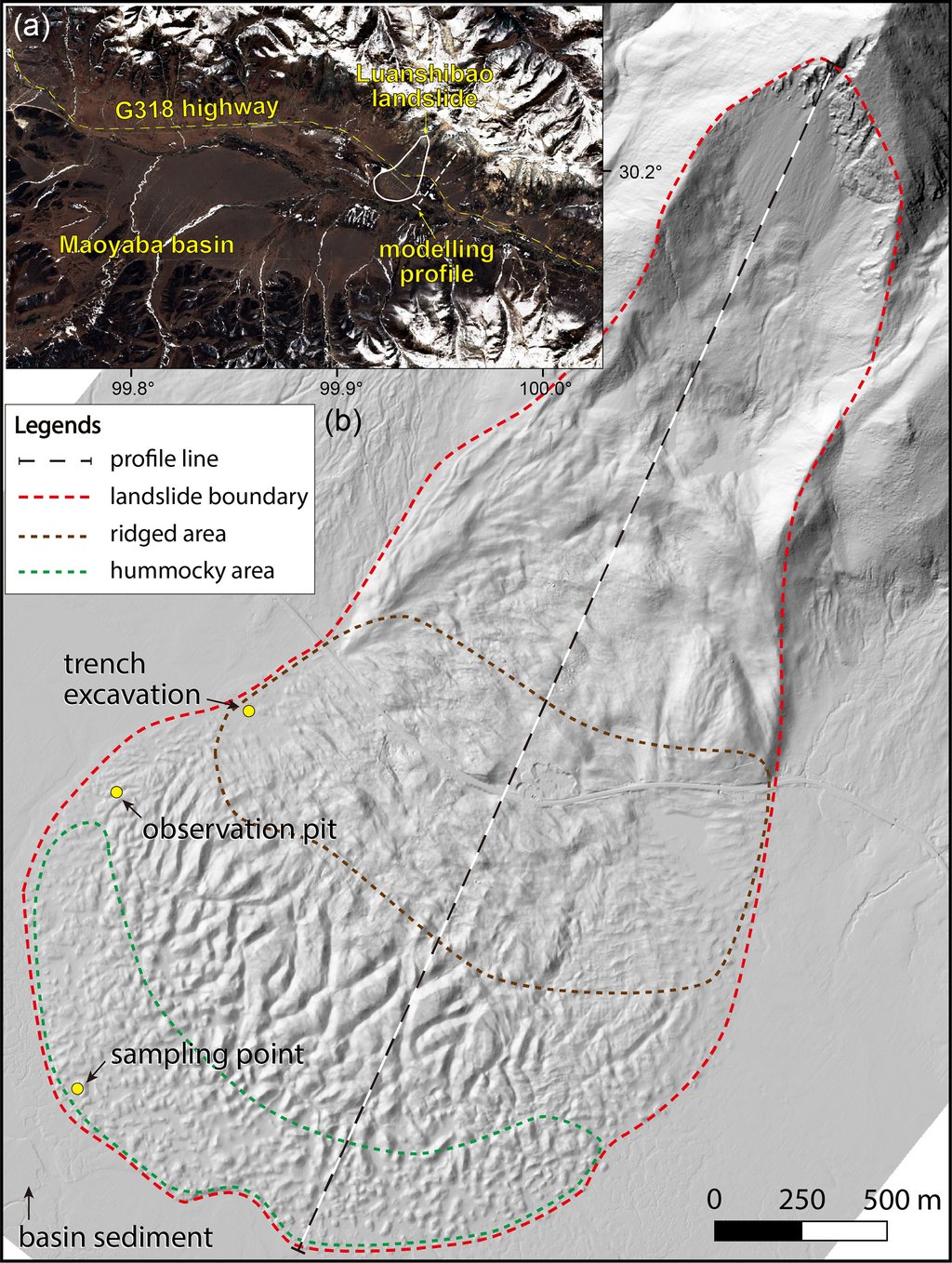
Ye Chen and Fawu Wang of Tongji University led the work, with colleagues at the University of Cambridge and the Chinese Academy of Geological Sciences. Writing in Natural Hazards and Earth System Sciences on Oct. 23, 2026, they locate the answer in water that was already in the valley floor. Their specific claim is about timing. They argue that the pressure which let that water carry the slide was generated by the blow of the landslide landing.
The idea that saturated sand under the Maoyaba Basin had something to do with this slide's reach is not new. It has been proposed before, and a 2022 study measured how readily sand from this basin turns fluid when it is shaken or sheared. What the new paper adds is the impact phase: the second or two in which a mountainside arriving off a steep slope meets soft, wet sediment at the basin margin.
The sand lets go when the water cannot escape
To get at that moment, the team trenched the deposit, took sand from the layer underneath and sheared it in a ring-shear machine, which can shear a ring of soil without limit. Sheared slowly, with the water between the grains free to drain away, the sand behaved like ordinary sand and held a friction angle of about 34 degrees. With drainage blocked, which is what happens when a landslide loads wet ground in seconds, water pressure built until it carried roughly 0.83 of the load the grains should have been taking, and the sand's resistance collapsed to an apparent 2.2 degrees. The authors note that even then it never fully liquefied under slow shearing.
Then they hit it. Three saturated samples, each pre-loaded to mimic conditions about six meters down in the sediment, took a blow of a fixed, five-second duration at three different strengths. The lightest was not enough: pressure leveled off short of the mark the slow tests had set, and the sample stopped moving. The middling blow and the hardest one both pushed past it, and both samples lost their strength completely. The surprise is in the clock. Under the middling blow, complete strength loss took about 20 seconds. Under the hardest, it took about 60.
Why would a harder blow work more slowly? The authors' reading is that a moderate impact breaks up the sediment's packed structure directly, and that generates pressure faster than the harder blow's route, which drives the sand to failure first and builds pressure as grains grind together. Their conclusion is hedged. They write that the farthest runout does not necessarily occur under the highest impact force, and that an appropriate impact level may exist which liquefies the ground beneath most effectively. They do not say what that level is, and the result rests on three tests, one per blow.
Every runout number here came out of a computer
None of that laboratory work measures runout. The travel distances come from a numerical model, as does every pressure figure in the paper that did not come off a test specimen. No water pressure was ever measured in the ground at Luanshibao. Because the shape of a mountainside that failed three millennia ago cannot be recovered, the modeled cross-section was rebuilt from an unfailed slope next door. In the benchmark run, the sliding mass punches about 10 meters into the sediment and drags sediment up into itself. Excess water pressure appears near the foot of the slope almost at the instant of impact, forming a slippery layer at its base that keeps the mass moving.
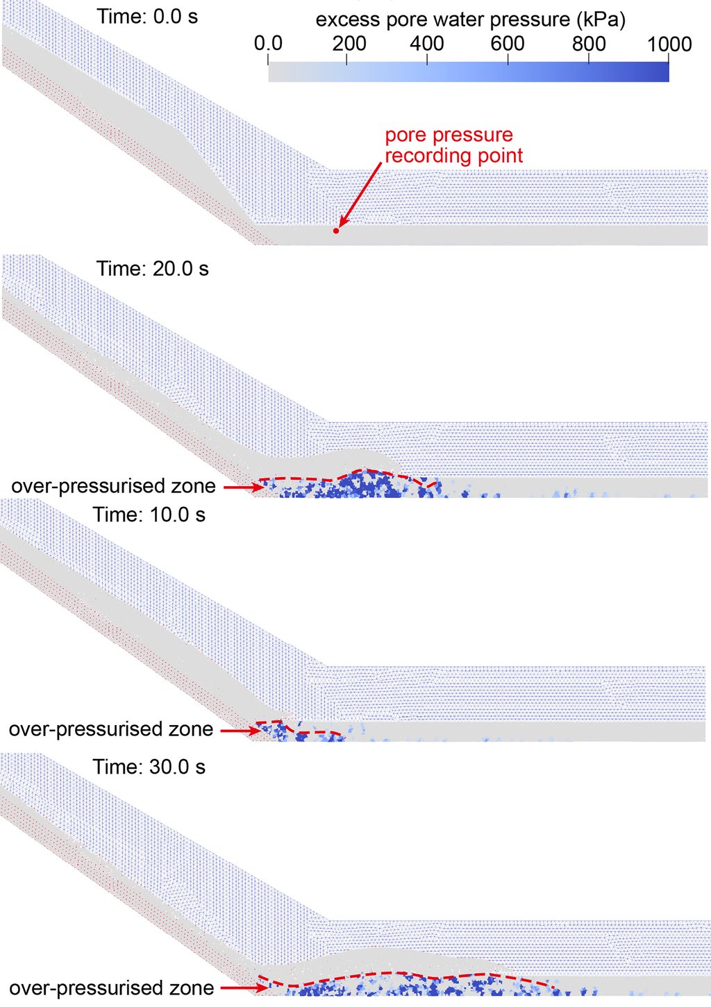
Varying the stiffness and compressibility of the two materials changed the outcome sharply. A stiffer sliding mass drove about 40 meters down into the sediment and shoved a bank of it ahead of itself, which stopped it. A more compressible one broke apart on landing, reached about 31 meters, scooped sediment into the moving body and kept going. Underneath both sits a finding that reads backward until the timing is clear: in the model, a less stiff sliding mass generates the higher water pressure, because a stiffer material shortens the impact and makes it more of a jolt. Those curves come from a single tracked point in the simulation, and that point moves as the run proceeds.
What a hazard assessment would have to ask
Runout models generally treat the ground a landslide crosses as something to be scraped up, not something to be struck, and the authors argue that leaving the blow out can misjudge the hazard. Their case is drawn for one setting: an alluvial basin, which is a valley floored with loose wet sediment and edged by a sharp break in slope. In that setting, a runout estimate has to account for what the floor is made of and how it responds, not only for the size of the slope above it.
Luanshibao itself is not finished. The source area is still creeping, and the deposit lies beside highway and railway lines. Independent support for the core mechanism comes from a slide within living memory. The Oso landslide in Washington state, on March 22, 2014, left hundreds of short-lived sand boils. They were a sign that the ground beneath the moving mass was under high water pressure as it was eroded. The Luanshibao team's raw test data are deposited publicly, and their simulations ran in open-source code, so another group can rerun the modeled half. The journal's full peer-review record for this paper is public.