A Hurricane Forecaster Split the Difference Between a Consensus Model and Google's AI

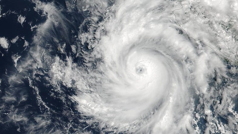
It was just before midnight in Honolulu on Sunday when the forecaster on duty at the National Hurricane Center wrote up his reasoning for Hurricane Karina's next advisory. Most of Discussion Number 16 is the ordinary craft of the job: fresh convection wrapping back around the north side of the storm, an eye trying to clear, a ridge parked to the north that will steer the hurricane west for days. One sentence in it is newer than the rest.
The track had been shifted left, Forecaster Papin wrote, "splitting the difference between the latest HFIP Corrected Consensus Approach (HCCA) and Google DeepMind (GDMI) guidance." A machine-learning model is now one of the aids a human forecaster weighs when deciding where a major hurricane will go, and on this cycle its pull on the official forecast is written down, by name, in a public document.
GDMI was one of two aids blended on one advisory cycle, and only for the track. The intensity forecast went the other way: NHC's numbers stayed "on the high side of the guidance envelope for a large portion of the forecast period, sticking pretty close to the latest HCCA intensity forecast."
The two aids it sat between are different kinds of object. HCCA averages about a dozen other models (the American and European global forecast systems, the hurricane-specific regional models, several statistical intensity schemes) and then applies corrections for the biases each is known to carry. GDMI is the mean of a 50-member ensemble from Google DeepMind's cyclone model, trained on reanalyses of historical cyclones rather than built up from the equations of motion. NHC's own model summary puts the class plainly: such systems are trained "to reproduce predicted atmospheric conditions and minimize errors in the training dataset." GDMI is listed as a member of the center's operational track, intensity and wind-radii consensus aids.
That arrangement is easier to check than folding machine learning into the models themselves, where a learned component's share of the answer is hard to separate out. Here the aid runs on its own, the forecaster takes it or leaves it, and what he did with it is on the record. Whether the blend helped will not be settled until the center verifies the season's guidance against the track Karina actually took.
Beyond the next 24 to 36 hours, the discussion says, Karina "might find itself in environmental conditions favorable for the hurricane to develop Annular characteristics, which could slow its rate of weakening despite the storm moving over gradually cooling sea-surface temperatures."
An annular hurricane is an unusually tidy one: a large, round eye inside a thick, even ring of thunderstorms, with few of the spiral bands that give most hurricanes their pinwheel look from orbit. John Knaff, James Kossin and Mark DeMaria named the category in Weather and Forecasting in 2003. Why it matters to a forecaster is in Papin's own sentence: a storm that settles into that shape can hold its strength while the water beneath it cools, which is exactly when the standard tools expect it to be coming apart.
The 125-knot initial intensity rests mainly on an automated satellite technique, the University of Wisconsin's Advanced Dvorak Technique, which had climbed to 129 knots. A human analyst at NOAA's Tropical Analysis and Forecast Branch, reading the same imagery by the older subjective method, came in far lower at 102 knots. Most of the other objective estimates were 6 to 12 hours old for want of recent microwave imagery, the same gap that left the forecaster unable to say whether Karina had begun an eyewall replacement cycle, the periodic rebuild of a hurricane's inner core that knocks its peak winds down for a while. The discussion cites satellite estimates only.
Hurricane-force winds reach about 40 miles from Karina's center and tropical-storm-force winds about 150 miles, and there are no coastal watches or warnings in effect. Swell travels much further than wind does. In the same advisory the center states that swells from Karina "will affect portions of the coast of southwest Mexico and the Baja California Peninsula for the next couple of days and will likely spread northward to southern California on Monday through midweek," and that they "are likely to cause life-threatening surf and rip current conditions." Its instruction to anyone on those beaches is to consult products from their local weather office.
Every number here belongs to a single advisory cycle. Karina was still strengthening when it went out, the next full advisory was due at 5 a.m. HST, and the intensity figures will be reworked months from now in the post-season best track. The sentence about splitting the difference will not be reworked. It is a dated record of what one forecaster reached for on a Sunday night, and of how narrowly he used it.