A Chilean Volcano's Glaciers Are Losing Ice 40% Faster Than Before 2000

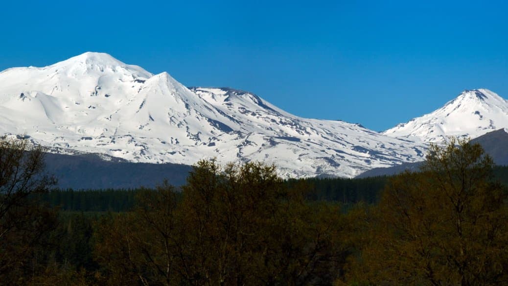
Around midday on March 12 and 14, 2024, at the end of the Chilean summer, Millie Spencer and Robert Clasing flew a small drone over the bare ice of a volcano in Chile's Ñuble region. The wind over the Cerro Blanco peaks was strong enough that the automated flight plan kept breaking down, and much of the survey had to be flown by hand. They had come for a number nobody had: not how much ground the ice still covered, which has been mapped for decades, but how much ice was actually left.
The answer, published Sept. 30 in the open-access journal The Cryosphere, is the first long-term record of ice loss for the Nevados de Chillán volcanic complex, a line of stratovolcanoes in south-central Chile. Spencer, a geographer at the University of Colorado Boulder, and colleagues in Chile and Germany found that the complex has been losing ice about 40% faster since 2000 than it did over the preceding half-century.
Glacier area on the complex has been tracked for years, and the fall is steep: Chile's Water Directorate puts it at 16.02 square kilometers in 1975 and 1.90 in 2019, an 88% loss. Those are the agency's inventory figures, which the study uses to draw its glacier outlines rather than measuring it itself. The count of glaciers has not fallen the same way. The agency still listed 28 in 2019; five had gone since 2000, while several on the Cerro Blanco subcomplex broke into more pieces than before. It is not clear, how many of the 28 still exist or are now hidden under volcanic debris.
To watch ice thin rather than merely shrink, the team stacked five surface maps spread across seven decades. The oldest is a military topographic map of Nevados de Chillán, drawn from aerial photographs taken in 1954 and existing only on paper; Alfonso Fernández of the Universidad de Concepción supplied the copy held in his department, which was scanned and traced contour by contour into a digital surface. Three maps came from satellites: radar from the Shuttle Radar Topography Mission in 2000, a stereo pair from the ASTER instrument in 2018, and Pléiades imagery from 2025 that the Water Directorate released under Chile's transparency law. The drone made the fifth, covering 11 of the 28 glaciers, on the western and southwestern faces of Cerro Blanco and Las Termas.
The ice is melting faster than it was
Averaged over the whole complex, the ice lost the equivalent of a layer of water 0.42 meters deep every year between 1954 and 2000, give or take 0.20. In the quarter-century since, the rate was 0.60 meters a year, give or take 0.38. That is the roughly 40% increase in the rate of loss. Both figures carry wide margins, wide enough to overlap, so the acceleration does not rest on the pair. What anchors it is a third comparison, against the 2018 satellite image, which gives 0.61 meters a year with a margin of only 0.06.
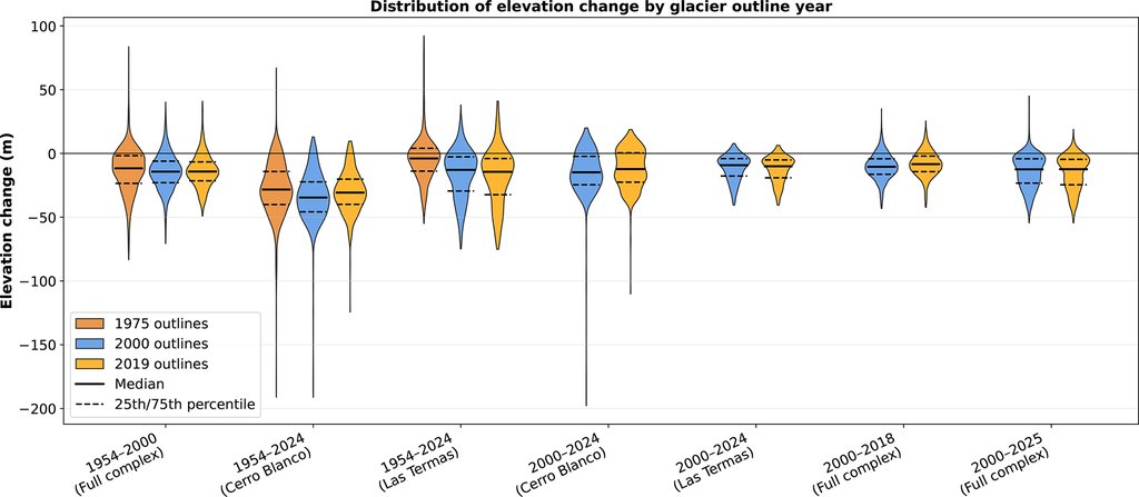
Loss was not even across the mountain. The Cerro Blanco subcomplex thinned faster than Las Termas in every period, and Glaciar Nevado, the largest glacier left, is going as fast as anything on the complex. The researchers also argue that their figures are conservative. A 2010 earthquake and later magma movement have lifted the complex by up to 45 centimeters, and ash and rock settling on the ice add height that is not ice; both push the measured thinning toward zero.
The river below is falling too
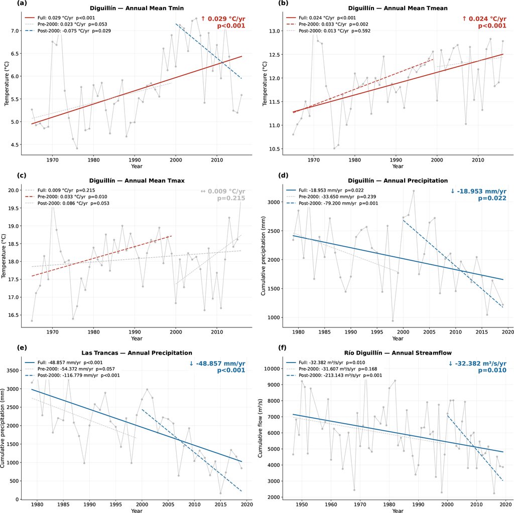
In the valley, the gauge on the Río Diguillín shows February and March flows dropping significantly since 2000. The authors chose those two months because that is when the previous winter's snow has usually finished melting, which leaves glacier melt as the summer's remaining source. A decline in these flows is consistent with the complex having passed peak water, the point where a shrinking glacier begins to deliver less meltwater each year rather than more, even as it melts faster.
They do not claim it has happened. Confirming that the river is falling because the ice is going would take a separate study of how much of the flow is glacier melt, and their own weather records offer a rival explanation: annual rainfall at the two stations nearest the complex has been falling by 79 and 117 millimeters a year since 2000. The paper's conclusion leaves peak water out altogether, saying only that declining summer flows coincided with accelerating ice loss and that measuring the glaciers' share of the river remains a job for later work.
What happens to that river matters more than the size of the ice suggests. Nevados de Chillán drains into the Itata basin, where agriculture takes 96.3% of the water consumed and irrigation demand peaks in late summer, when the rain has all but stopped and glacier runoff is at its highest. Those figures come from earlier work on the basin, cited in the study rather than measured by it.
Now there is something to measure the next decade against
Small glaciers like these are easy to lose in an average. Nevados de Chillán already sat inside four regional surveys of Andean ice, and the new complex-wide rate falls within the range those surveys report for the southern Andes. However, none of those surveys could isolate a single volcano from a continental average, on a mountain where geothermal heat, falling ash and the direction a slope faces all pull in different ways.
The result is a baseline where there was none, and an unusually checkable one. The elevation data and the analysis code are publicly available on Zenodo, so a water agency in Ñuble or the next team with a drone can redo the comparison instead of starting over.