The Atlantic Has Waited Longer for a Hurricane Than in Any Season Satellites Have Watched

The busiest day of the Atlantic hurricane season, by the long-run average, is September 10. That day came and went with no hurricane anywhere in the basin, and so did the day after it. When September 11 passed, the Atlantic had waited longer for its first hurricane of the year than in any season since satellites began watching it.
That record is not NOAA's. No National Hurricane Center or Climate Prediction Center product says the Atlantic has set one. The record is kept by Philip Klotzbach, a hurricane specialist at Colorado State University's Tropical Meteorology Project, and his count starts in 1966, when satellites began covering the basin routinely enough to catch every storm. What the agencies supply is every piece the count is built from, and each piece holds up.
Five storms have been named in the Atlantic this season: Arthur, Bertha, Cristobal, Dolly and Edouard. The hurricane center's advisory archive for the season lists all five as tropical storms and not one as a hurricane, while the same table lists hurricanes in the eastern Pacific. So the record measures a line that has not been crossed rather than an empty ocean. A tropical storm becomes a hurricane when its sustained winds reach 74 mph (119 km/h). Storms have formed. None has crossed it.
The previous record date was September 11, and the Atlantic reached it twice. In 2002 a hurricane center bulletin that day was headed "GUSTAV BECOMES THE FIRST HURRICANE OF THE 2002 SEASON." In 2013 the same job fell to a bulletin reading "HUMBERTO BECOMES THE FIRST HURRICANE OF THE SEASON." The two are not an exact tie. Gustav was upgraded later in the day than Humberto was, which is why that season is usually named as the one that held the mark.
The 1966 start is not a footnote to hurry past. Before satellites watched the basin continuously, and before aircraft flew into storms as a matter of routine, a hurricane that spun up over open water with no ship near it was never written down. Earlier seasons cannot be set beside this one as equals, which is why the record carries a start year at all.
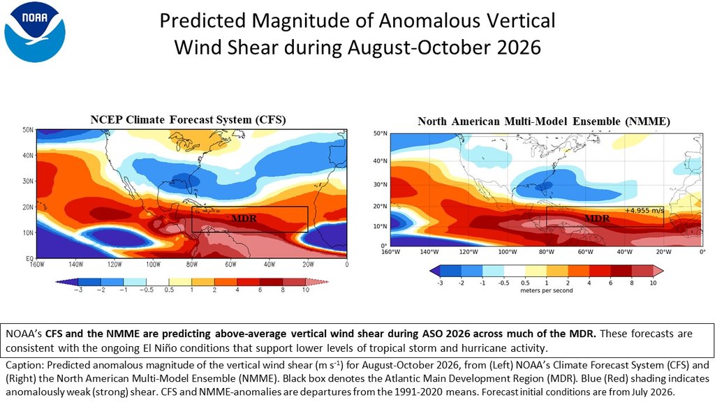
A quiet season was in the agency record long before the peak arrived. NOAA's Climate Prediction Center issued its updated outlook for 2026 on August 6 and built it around El Niño, a warming of the eastern Pacific. The outlook states that every Atlantic season coinciding with a strong El Niño since 1950 has come in below normal. It also gives the reason. El Niño cancels out the gentle high-altitude winds the Atlantic would otherwise enjoy, and the models behind the outlook predict stronger-than-usual high winds across the belt of ocean where most Atlantic storms form.
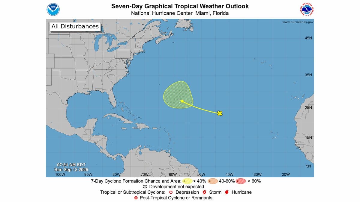
That quantity has a name: wind shear, wind that changes with height. It is hostile to a storm trying to organize, and the hurricane center said as much on the morning of September 13 about the single disturbance it had on its board, a trough in the central subtropical Atlantic. Conditions there were "not currently favorable for development due to strong upper-level winds." Benjamin Kirtman, dean of the University of Miami Rosenstiel School of Marine, Atmospheric, and Earth Science, described the basin to The Philadelphia Inquirer as having "hostile shear conditions."
Klotzbach's own measure of that wind is extreme. In figures he published on September 10, the average shear over the western Atlantic and the Caribbean for the previous 30 days ran more than 3 knots above any other year in his record. That record begins in 1979, which is not the year the storm count begins, and the difference matters. Satellites began watching the Atlantic basin closely enough to catch every storm in 1966; the global satellite data behind a map of the wind only reach back to 1979. Two records, two datasets, two start years.
Kirtman also noted the timing. "Whereas El Niño episodes typically ramp up toward the peak of hurricane season, this event was already in place and strengthening well before the season's most active months," he told the paper. Whether El Niño is the reason for this particular record, though, is a forecaster's reading rather than a finished analysis. Klotzbach told the same paper the quiet "is almost 100% El Niño." No formal attribution study of this season's drought exists.
One thing NOAA did not do is forecast an empty basin. Its August outlook called for a below-normal season, with 2 to 6 hurricanes in it. With the peak behind it, the Atlantic has run past the quiet end of that range.
The Pacific end of this has not eased. The Climate Prediction Center's update on September 10 has an El Niño advisory in force and puts the chance of a very strong event through the fall and winter above 90%.
In the Atlantic, the hurricane center's outlook on
the morning of September 13 showed no tropical cyclone at all, and gave the one disturbance on the map effectively no chance of developing within two days and a 20% chance within seven. The season runs to November 30, and NOAA's outlook makes the point that applies to any quiet year: it only takes one hurricane, or one tropical storm, to cause a disaster. The record itself is settled and cannot be undone, and every further day without a hurricane only makes it longer.