The Hill North of Taipei Is Built From Its Own Collapses

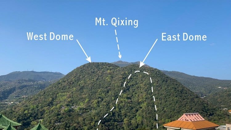
A geologist arriving at Mount Shamao finds almost nothing to look at. The hill is about a kilometer across, at the northern edge of greater Taipei, and subtropical rain, forest and housing have left it with almost no exposed rock. It is also one of the youngest pieces of the Tatun Volcanic Group, the volcanic field that sits above Taiwan's capital region. What little could be read off the hill suggested a simple story: a lava dome that had slumped once.
That story has now been taken apart. Huai-Yu Tang, Kerry Sieh and colleagues at National Taiwan University, Academia Sinica and the University of Wisconsin-Madison published a reconstruction of the hill on Oct. 17, 2026, in Bulletin of Volcanology. They worked mostly from the shape of the ground, using a bare-earth terrain map built from an airborne laser survey flown by Taiwan's Geological Survey and Mining Management Agency.
The map shows not one landform but three. Two lava domes overlap, East Dome and the younger West Dome on its flank, and an older, flatter flow spreads off their southwestern base. The smooth skirts that fall away from the domes are not solid lava either. They are the domes' own wreckage.
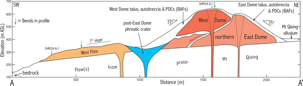
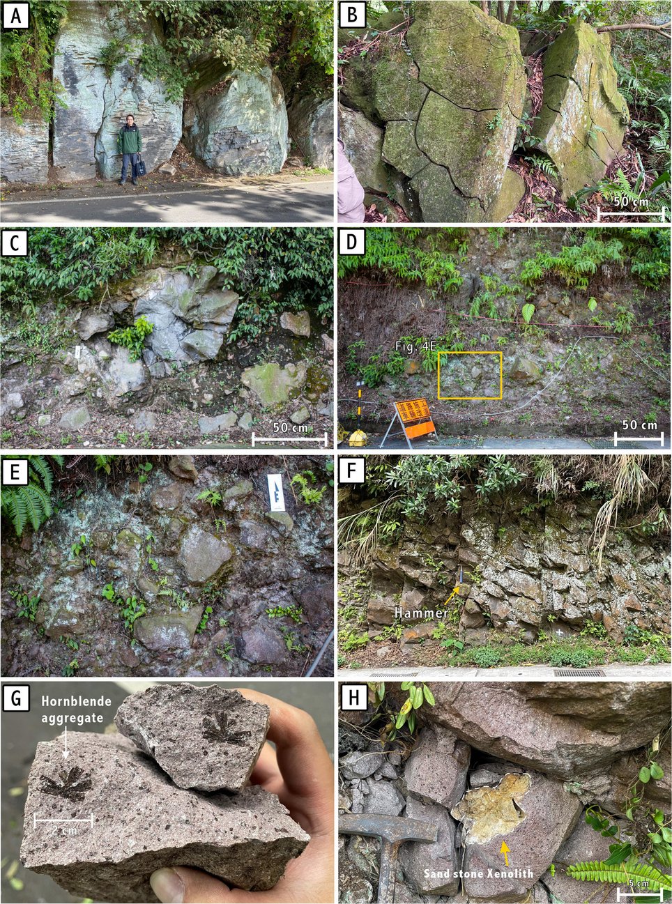
The evidence underneath comes from a borehole the government agency drilled years ago, BH-15, which the team re-interpreted from photographs the agency posts publicly. In its top 100 meters, the core carries no lava at all. It consists of broken, angular blocks of andesite in a disordered matrix, stained purple-red by heat. That is the signature of a block-and-ash flow, an avalanche of hot rock, ash and gas shed off a collapsing dome. Two buried weathering surfaces interrupt the pile, and the authors read them as short pauses between separate collapse pulses.
The dates have never agreed
The paper's own summary of the earlier work is blunt: published ages for the same rocks contradicted one another. Zellmer and colleagues reported 1,367 years for the Shamao complex in 2015, from magnetite crystals, and 18,000 to 33,000 years from other minerals in the same sample. A zircon study put the hill far older, at an age its authors flagged as uncorrected for a known bias. Belousov and colleagues, dating lake mud trapped behind a landslide off the hill's southern flank, set a minimum of about 16,000 years.
The new chronology comes from argon, measured at the WiscAr laboratory in Wisconsin on the fine-grained rock between the crystals. The older flow gives 196,400 years, give or take 2,300. The eastern dome gives 24,200 years, plus or minus 1,800, which puts the dome building some 170,000 years after the flow and keeps the whole history inside the Pleistocene, the long ice-age epoch.
That second number is not settled, and the paper does not pretend it is. A separate team led by Karl D. Jabagat dated the same dome in March 2026 with two zircon methods, getting 16,300 years from each, and 15,000 years for the western dome by argon. Tang and colleagues argue theirs is the more precise measurement: their sample gave up far more of the argon that actually dates the rock than the rival experiment, whose own uncertainties are wide enough to overlap the new age. They leave the question open rather than settling it. "Further high-precision chronology of the Shamao complex will be needed," they write.
The lava was too stiff to flow
The mechanism the team proposes turns on how stiff the lava was. Counting crystals under a microscope put the older flow at about 47% crystals and the dome lavas at roughly two-thirds. Past about that point, lab work on crystal-packed melts finds, a magma stops behaving like a liquid and locks up. The flow, below the limit, could spread sideways into the low pancake the laser map shows. The dome magma could not. It was forced up as steep spines that broke apart as they rose, shedding the avalanches now buried in the core. That chain is the authors' reading of their data, not a measurement.
Behind all three units, the team reads a reservoir of crystal sludge, part crystals and part melt, in the middle or upper crust. The flow and the domes differ slightly in chemistry and in which minerals they carry, which is hard to explain if one batch of magma simply cooled and evolved into the next. The 170,000-year gap makes it harder still. Easier, the authors argue, is that each eruption tapped a different part of the same sludge, off and on, over ten to a hundred thousand years.
The hazard stays close to the hill, unless a valley carries it
On hazard, the paper is careful about its own reach. The domes and their explosion craters do not extend much more than a kilometer from where they erupted. The collapse off the eastern dome's west flank traveled at least 2 kilometers southwest, into a valley that drains toward the northern Taipei basin. Whether it went farther, the authors decline to say; they write that they have not attempted to determine whether the collapsed mass and its flows continued downstream into the Taipei metropolitan area. They found no trace of the large explosive eruptions that bury a region in ash, and named collapse avalanches as the main and most frequent hazard of a dome like this one.
Nor does any of this point to an eruption soon. No eruptive age younger than 10,000 years has been identified from the group's volcanic rocks, the paper says, citing two earlier studies. That negative is narrower than it sounds: it is a statement about dated rock, not about a sleeping volcano. Other work reads the record differently, and the 2021 seismic study these authors rely on for the magma's depth opens by citing evidence for a last eruption around 6,000 years ago elsewhere in the field.
What the paper does say is that the system is alive. It calls the Tatun group "likely to be an active volcanic system," with a mush of crystals and melt imaged in the crust beneath it, and warns that "future recharges could trigger highly unpredictable effusive or explosive events." Huang and colleagues found that partly molten zone with earthquake waves in 2021; Lin and colleagues put the top of the eruptible part of it at 13 to 15 kilometers down in 2025. Jabagat's team, reading the crystals themselves, puts the storage much shallower, and the question is unsettled.
Most dome fields in wet climates have Shamao's problem: the deposits that record their collapses are buried, eroded or overgrown. That is why the hill was read as a single slump for so long. The method here, a laser map of the ground read together with the crystal content of what little rock is exposed, is offered as a way into those places, where hazard assessment leans on a volcano's own eruptive record and that record is mostly out of sight.