Robotic Sentinels for Collapsing Mountains: The Blatten Test Case

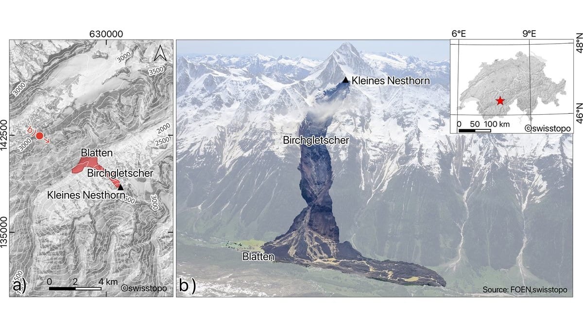
On 28 May 2025, a mountainside above the Lötschental valley in southern Switzerland gave way. Rock had been loading onto the Birchgletscher for years; when the glacier finally failed, roughly 9.57 million cubic metres of rock and ice swept down and buried large parts of the village of Blatten. The debris dammed the river Lonza, ponding a new lake behind it, and the economic toll was later put near CHF 320 million.
Within about a day, a drone dock was hauled to the valley and switched on. From 1 June to 18 November 2025 it (and a second dock) flew twice a day, entirely on their own, photographing the unstable pile of debris and measuring how it was still settling. No pilot stood in the field. That deployment is the centrepiece of a study published on 6 July in Natural Hazards and Earth System Sciences, and it shows how the drones arrived after the collapse. They watched the aftermath, not the failure itself. What Blatten demonstrated was the speed of a rapid, hands-off deployment onto fresh, still-moving hazard deposits, not a warning that saved the village.
Led by Alexander Maschler and colleagues at the Western Norway University of Applied Sciences, the work is framed as the first systematic field evaluation of dock-based drones for geohazard monitoring in steep terrain: self-charging aircraft that live on the mountain rather than being carried up for each survey.
What "self-charging drone in a box" actually means
The hardware is commercial: a DJI drone dock (a ruggedised, weatherproof enclosure) paired with a multirotor aircraft carrying a 20-megapixel camera and centimetre-grade satellite positioning. Between flights the drone sits inside charging; on a schedule, or on command, the lid opens, the aircraft lifts off, flies a preplanned grid over the hazard, lands itself, and recharges. A built-in weather station can veto a launch when wind or precipitation would spoil the imagery. The dock draws only 50 to 100 watts on standby, spiking to around 1,200 watts while charging. That is modest enough to run off a small off-grid supply.
The photographs feed two processing routes. One, structure-from-motion photogrammetry, stitches overlapping images into 3D point clouds, orthophotos and surface models. The other, a neural-rendering technique called Gaussian splatting, builds a fast 3D view for quick visual assessment. Comparing successive surveys then reveals what moved and by how much, using a point-cloud comparison algorithm (M3C2) for 3D change and an optical-flow method for horizontal displacement.
Centimetres, repeatably
Across the three sites the smallest reliably detectable change (the level of detection at 95 % confidence, or LoD95) sat mainly below 0.10 metres, averaging about 0.07 to 0.08 m. The photogrammetry reached roughly ±5 cm over a survey area of several square kilometres. In hazard terms, that means movements of a handful of centimetres between two flights stand out from the noise, and with twice-daily flights those flights come often.
The three sites were chosen to span the kinds of ground that kill people in mountains. At the Supphellebreen icefall in western Norway, an outlet of the Jostedalsbreen ice cap, the drones tracked ice creeping downslope at 0.4 to 1.5 metres a day, and caught seracs (unstable ice towers) accelerating to more than five times their normal speed before breaking off. At Skjøld, a complex, slowly failing rock slope, annual movements stay below a metre, the kind of slow creep that only patient, repeated surveying can resolve. And at Blatten, the deposits were still settling at about 0.05 m a day when monitoring began, easing off over the months that followed.
The honest ceiling on "early warning"
It is tempting to read serac acceleration or a creeping rock slope and conclude the drones can call a collapse in advance. However, what the authors write is that automated drone monitoring "can supply authorities with actionable technical data before, during, and after disasters" and could strengthen "the analytical basis for early warning"; that is the potential to feed a warning system, not a demonstrated warning that changed an outcome. The precursory signals are real and were captured; turning them into reliable, acted-upon alerts is future work the authors explicitly assign to later research.
They are equally frank about the obstacles that have nothing to do with cameras or algorithms. Broader adoption, they write, hinges on legal frameworks for routine automated flight, fair access to the technology, trained people to run it, and public acceptance of drones humming over the valley. A box on a mountain that flies itself is a genuine step past the occasional field campaign, but it is a step, not a finished early-warning network.
Still, the direction is clear enough to matter. Much mountain hazard monitoring is limited less by what instruments can measure than by how often someone can get to the site. A system that surveys a moving glacier or a fracturing cliff twice a day, at centimetre accuracy, without a pilot in the field, closes exactly that gap. The Blatten deployment showed it can be stood up on fresh, dangerous deposits within a day of a disaster. Whether such sentinels are watching the next Blatten before it falls is now a matter of deployment and regulation, not of whether the technology can see.
Sources
- Natural Hazards and Earth System SciencesPeer-reviewed