Every Monitored Lake in China Read Normal. That Is How Scientists Ruled out the Cause Everyone Assumed.

Zhang Qianggong was chairing a regional cryosphere meeting in Chengdu on the morning of 26 August when messages began going around a work chat group. His first thought was that it looked like an earlier, smaller landslide. Then a video came from a herder on the Chinese side of the border, showing ice and rock coming down a mountainside. He went straight to a collaborator's office, and they opened the glacial-lake observation platform and pulled the real-time data for the dangerous lakes upstream, one at a time.
Every lake level inside China was normal. Nothing had emptied, and that is what settled the question. The sheer volume of water coming down the valley had produced immediate speculation that a glacial lake had burst; the platform said none had. Zhang, who heads climate and environmental risk at the International Centre for Integrated Mountain Development, told Red Star News that the live data from several dangerous upstream lakes came back normal, and that this ruled the possibility out.
What actually happened was recorded rather than anticipated. Seismometers around the world registered a signal that the U.S. Geological Survey first logged as a magnitude 4.4 earthquake. Analysis of long-period seismic waves and satellite imagery changed the entry: the agency re-catalogued it as a magnitude 5.2 landslide and stated that no earthquake had occurred. Germany's GFZ Helmholtz Centre for Geosciences, reading its own GEOFON network, put the same event at 5.69 Mw, a different magnitude scale on a different network, not a rival account of what happened.
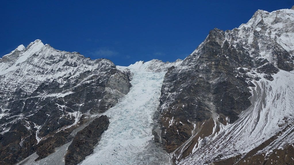
The source was a hanging glacier and the rock beneath it, on the north flank of the Langtang massif. Dan Shugar, a geoscientist at the University of Calgary, compared satellite images from before and after and put the break at about 5,200 meters, with the mass falling more than a kilometer to the valley floor. What failed was not only ice. "You have this big bedrock failure that took part of the glacier with it," he said. Friction melted the ice almost instantly, and the mud and debris flow that formed ran down the Lhende Khola at more than 130 kilometers an hour, flattening the Gyirong border post in under ten minutes. Hundreds are dead and hundreds more missing, with counts rising and differing between the agencies reporting them.
The platform was built for lakes, and this was not a lake
That monitoring is young. Gyirong was hit last year as well, by the outburst of a lake sitting on the surface of a glacier, a type of event Zhang says scientists had not met before. Tibet and the Shigatse authorities put substantial money into a lake observation system afterwards. A collaboration between the Chinese Academy of Sciences and the Institute of Mountain Hazards and Environment in Chengdu has preliminarily identified 183 relatively dangerous glacial lakes across the Tibetan Plateau. Identified is not the same as instrumented. Shigatse itself has between 20 and 40 online stations measuring water level and weather on a single warning platform, most of them installed within the past five years.
All of it watches lakes. Zhang was direct about the limit. The glacier that failed is not inside China; there was no effective observation of it; and a glacial-lake warning system does not cover a glacier collapsing outright. Alton Byers, a mountain geographer at the University of Colorado Boulder who organizes research expeditions in the Himalaya, said the same: the glacier that broke off had not been heavily studied or closely watched. "You can't predict these events," he said.
A 2019 paper had already named the county
The gap is not for want of a survey. In 2019 a team led by Simon Allen at the University of Zurich, with Tandong Yao and colleagues at the Chinese Academy of Sciences, screened 1,291 glacial lakes across the plateau and ranked them for danger. It named a hotspot in the central Himalayan counties of Jilong, Nyalam and Dingri, and flagged the trans-boundary threat to communities downstream in Nepal. Jilong is Gyirong. But that work ranked lakes for glacial lake outburst floods, and the flood of 26 August had no lake in it at all.
GFZ makes the general point: almost every Himalayan disaster of recent years began at a source that had not been classified as dangerous. Watching lakes presupposes that the dangerous ones can be identified in advance. The institute's alternative is to listen. A seismic network registers the shaking a large flow makes, needs no prior knowledge of where the water will come from, and reaches across a border. For one earlier disaster, a mass-wasting and flood in Uttarakhand, India, on 7 February 2021, GFZ researchers calculated afterwards that a real-time system could have given up to 11 minutes of warning. That was for the place where most people died, a hydropower plant then under construction. The analysis was published in Science, and GFZ is proposing a monitoring program of its own along these lines.
Nothing of the kind was running on 26 August. Niels Hovius, who heads geomorphology at GFZ, put the counterfactual plainly. Events like this cannot be prevented, he said. But a seismic early-warning system could have issued downstream warnings within minutes of the collapse, giving people between a few minutes and several tens of minutes to reach safety. It gave them none, because it does not exist.
The sequence itself is still in dispute
Two accounts of the order of events are on the record, and they do not agree. Nature, citing The Kathmandu Post, reports that satellite images passed from China to Nepal show an ice landslide blocking the Lhende Khola and forming a temporary lake that then burst. Zhang's reading is different. He thinks it was a direct ice-and-rock avalanche. There is at present no substantive information proving whether the block-then-burst sequence happened, he says, and judging by the energy involved he considers it more likely that the avalanche ran straight downstream, with the debris forming a barrier afterwards. The two accounts agree on one point: no pre-existing glacial lake was involved.
Attribution is at a similar stage. Kristen Cook, of Université Grenoble Alpes, said that "while we cannot at this point directly link this collapse to climate change, it is not unexpected to see more events of this type with a warming climate," before adding: "Not this big, hopefully not this big." Mohd Farooq Azam, a senior cryosphere specialist at ICIMOD, called it too early to determine what role climate change played in this particular event. Göran Ekström, a geophysicist at Columbia University, goes further, saying that melting glaciers and permafrost in the Himalaya probably contributed. Byers goes further still, as his own reading of it: thawing permafrost, he argues, is weakening rock and ice it has held together for millennia.
The site is not finished. Debris has dammed the channel, and water is impounded behind it; how much, Zhang said, is not currently clear, and whether it overtops or breaks through will need close monitoring. Unstable hanging ice remains on the slope above. About three hours after the first collapse, the USGS catalogued a second landslide at the same coordinates, magnitude 4.2. That one, too, was recorded after it happened.